Pompeii Maps, Plans, Guides
Press the plan photo to see a larger resolution version
A second press on the larger version will enlarge it further if available
Pompeii 1st-4thC AD
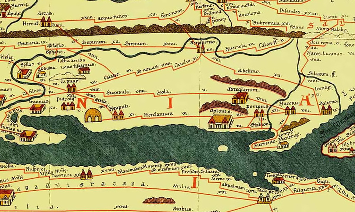
Plan of Pompeii 1-4C AD from the Tabula Peutingeriana, 1-4th century CE. Facsimile edition by Conradi Millieri, 1887-1888. Wikimedia.

Pompeii 1776
The first plan of Pompeii published in February 1776 by Francois-De-Paule Latapie. He drew the map from memory after visiting Pompeii, as such activities were not allowed during visits at that time, and made a presentation to l’Académie Reale di Scienzi, Lettere ed Arte de Bordeaux.

Pompeii 1785
There are several versions of this plan by F. Piranesi between 1785 - 1792 judging by the written key in the bottom left. This is the first we have.

Pompeii 1788
There are several versions of this plan by F. Piranesi between 1785 - 1792 judging by the written key in the bottom left. This is the second we have.

Pompeii Between 1788-1792?
There are several versions of this plan by F. Piranesi between 1785 - 1792 judging by the written key in the bottom left. This is the third we have.

Pompeii 1792
There are several versions of this plan by F. Piranesi between 1785 - 1792 judging by the written key in the bottom left. This is the fourth we have.

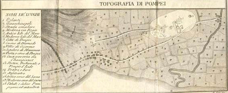
Pompeii 1800-1810.
Pompeii plan of around 1800 to 1810 by Francesco La Vega (1737-1815). Photo courtesy of the Deutsches Archäologisches Institut.

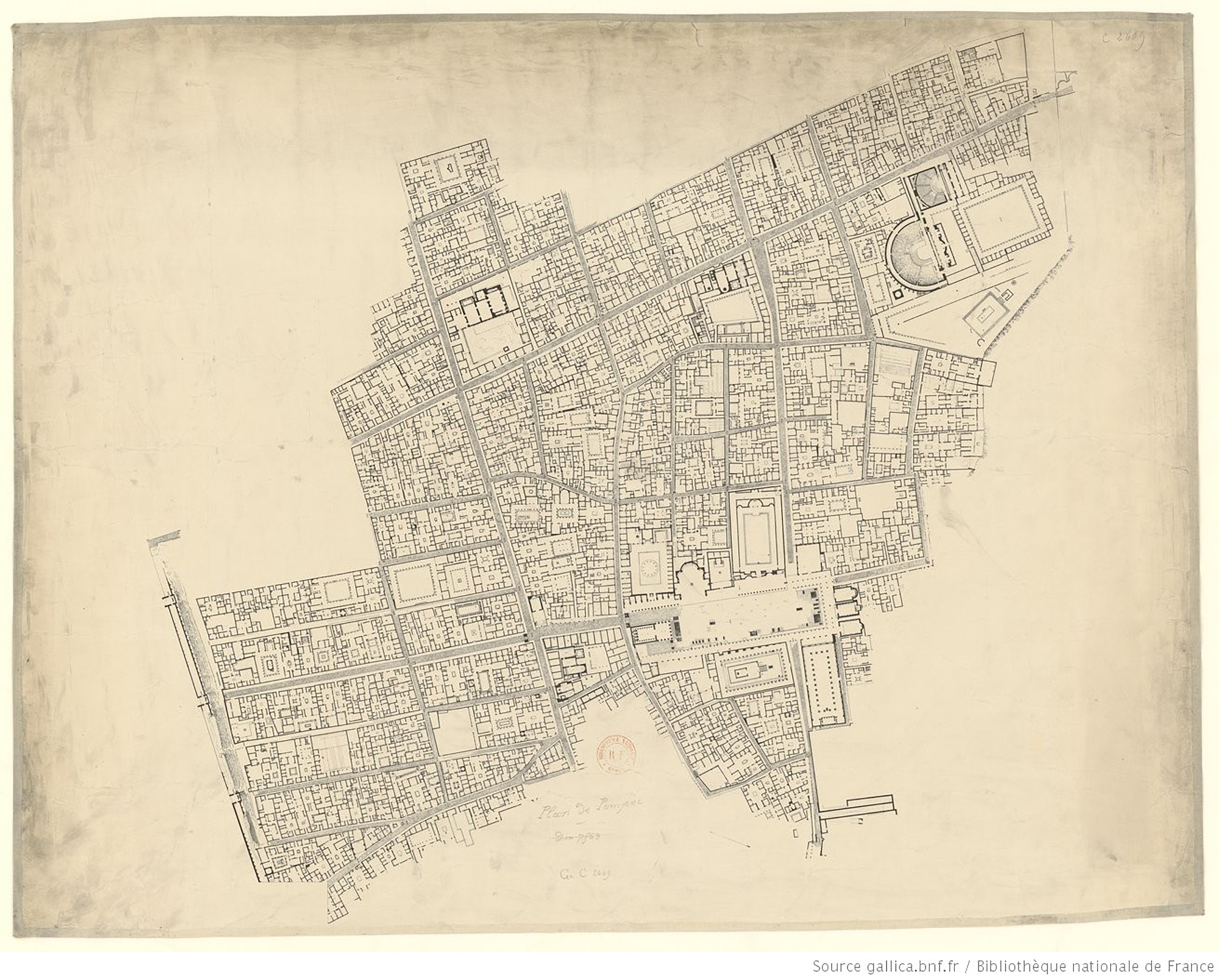
Pompeii early 1800s?
Undated plan of Pompeii. Possibly around 1800?
Photo courtesy of Gallica.bnf.fr.
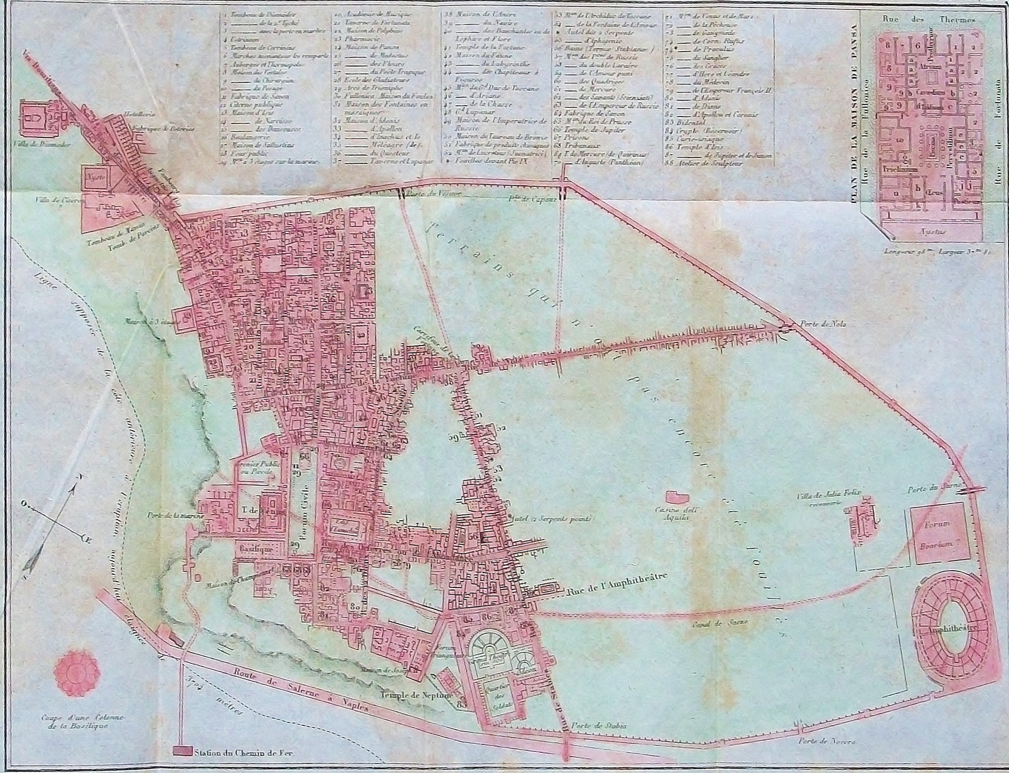
Pompeii c.1800 to 1810.
Pompeii plan by Francesco La Vega (1737-1815). Now in MANN. Photo courtesy of the Deutsches Archäologisches Institut (76.1259).

Pompeii index to plan c.1800 to 1810.
Index of Pompeii plan by Francesco La Vega (1737-1815). Photo courtesy of the Deutsches Archäologisches Institut (76.1260).

Pompeii case pseudosuburbane c.1800 to 1810.
Detailed part of Pompeii plan by Francesco La Vega (1737-1815). Photo courtesy of the Deutsches Archäologisches Institut (76.1264).

Pompeii Porta Ercolano c.1800 to 1810.
Detailed part of Pompeii plan by Francesco La Vega (1737-1815). Photo courtesy of the Deutsches Archäologisches Institut (76.1263).

Pompeii Insula Occidentalis c.1800 to 1810.
Detailed part of Pompeii plan by Francesco La Vega (1737-1815). Photo courtesy of the Deutsches Archäologisches Institut (76.1262).

Pompeii Theatres c.1800 to 1810.
Detailed part of Pompeii plan by Francesco La Vega (1737-1815). Photo courtesy of the Deutsches Archäologisches Institut (76.1261).
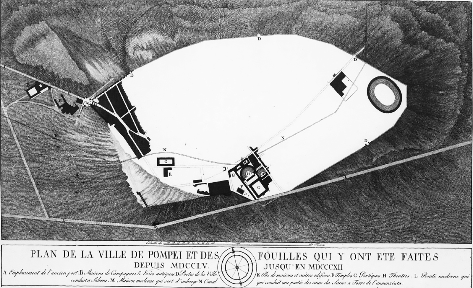
Pompeii 1804
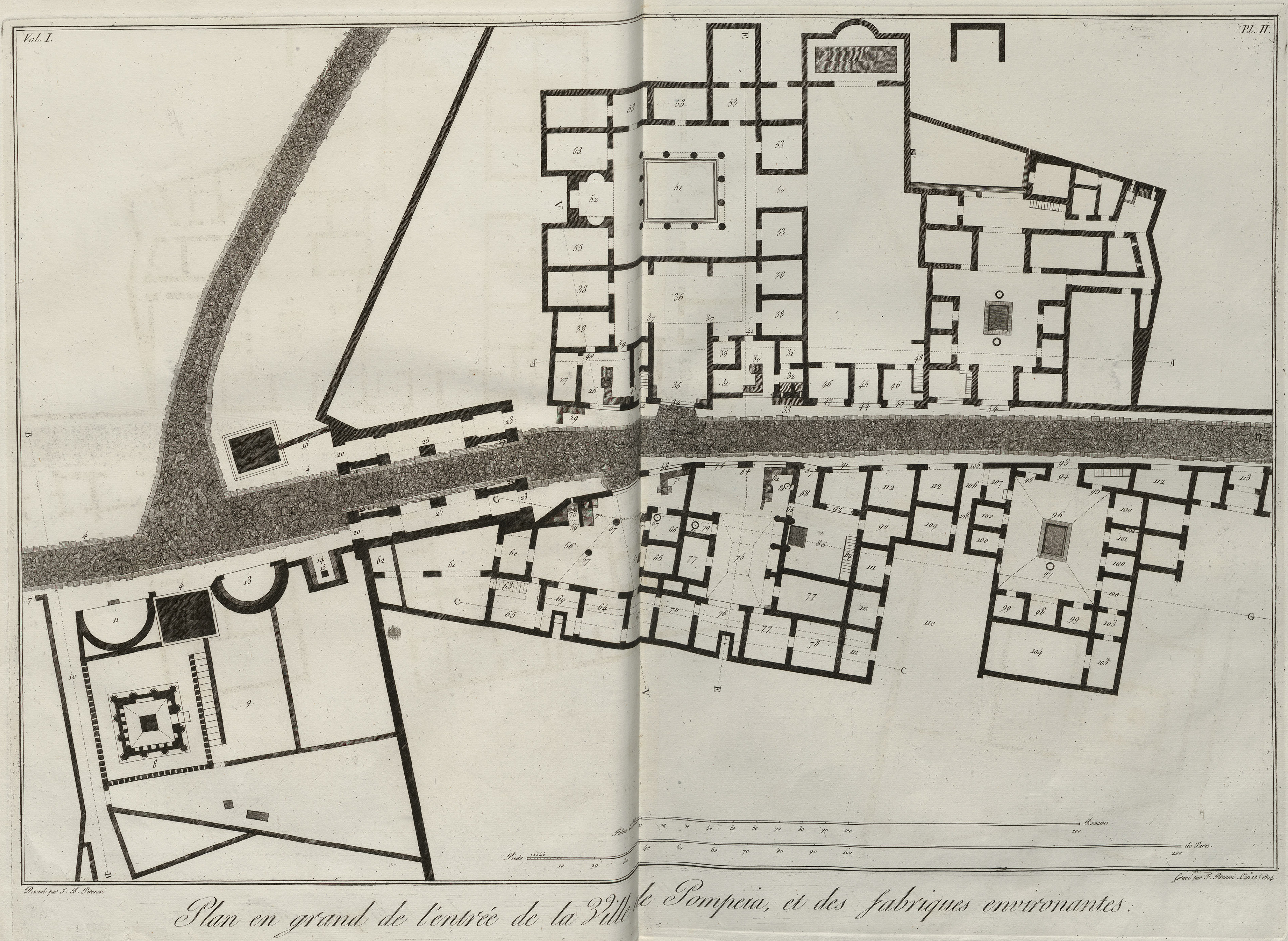
Plan showing entry to Pompeii and its surrounding remains by G. B. and F. Piranesi, 1804.
Pompeii 1807
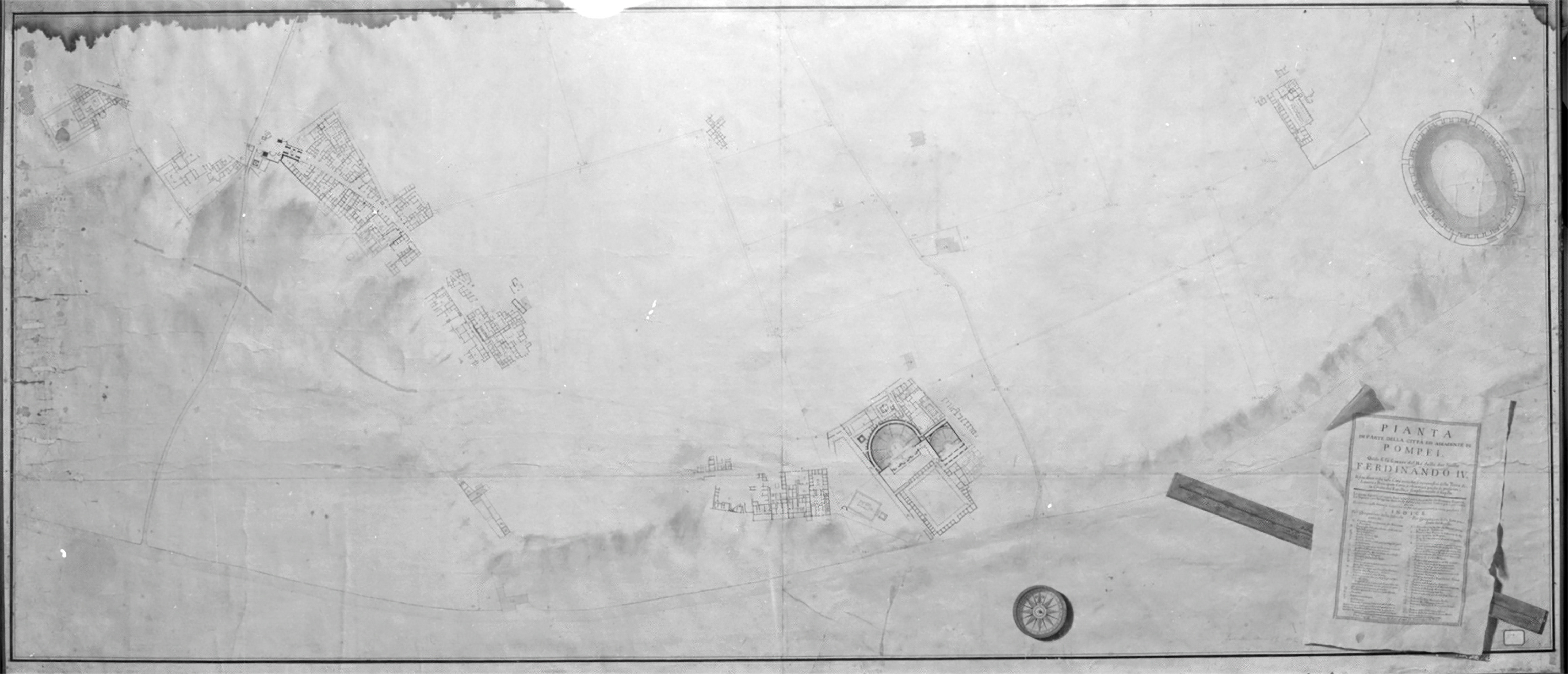
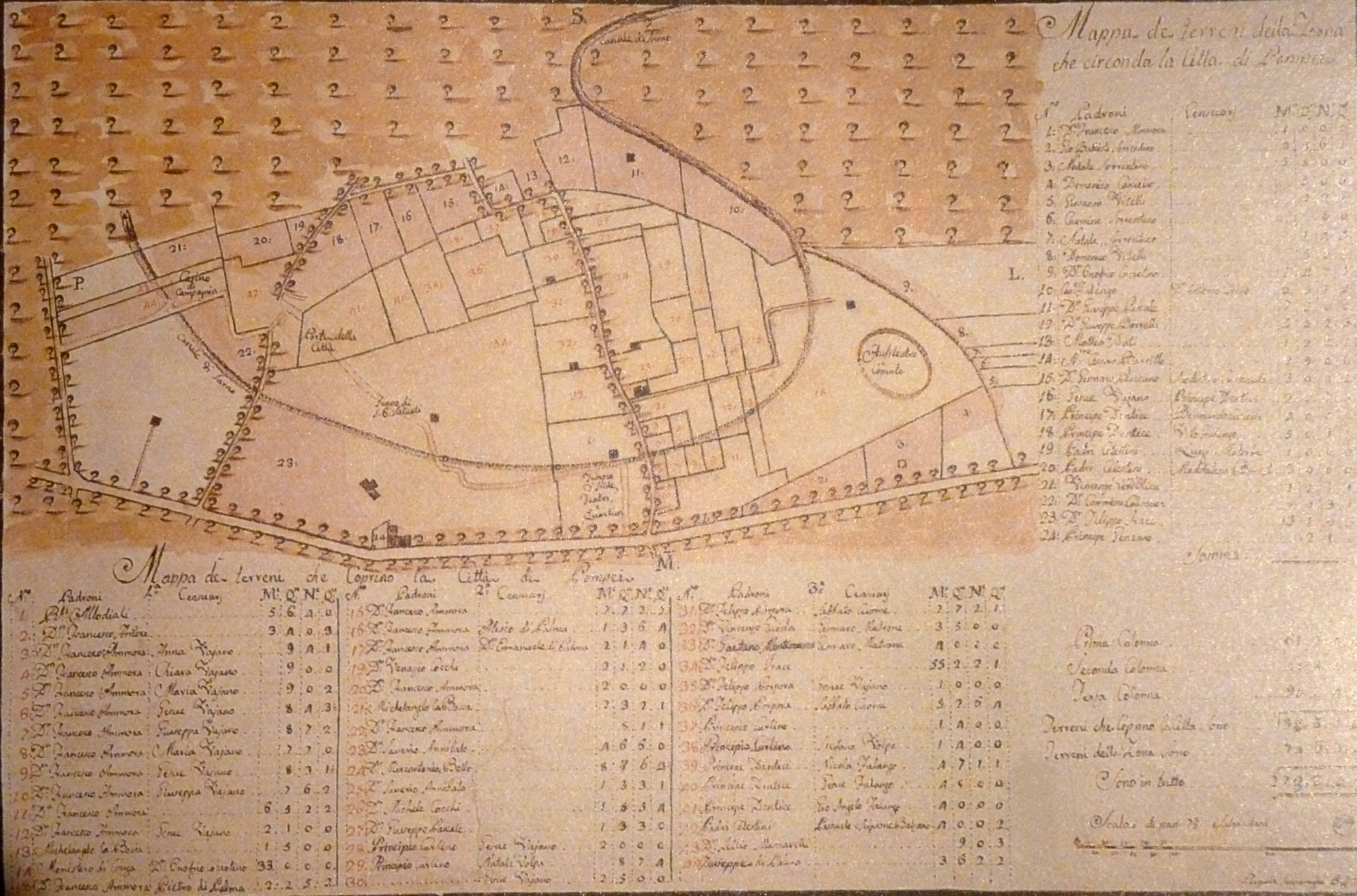
Plan of the land that covers the city of Pompeii drawn by Pasquale Scognamiglio, 1807.

Pompeii 1807
Redrawn plan, with clear numbers, of the land that covers the city of Pompeii on the plan drawn by Pasquale Scognamiglio, 1807.
See Kockel V., Funde und Forschungen in den Vesuvstadten 1, Archäologischer Anzeiger, I985, p. 517, abb. 9.

Pompeii Extra Porta Herculanensiem 1809
Plan of the area outside Porta Ercolano by La Vega 1809 1763-1770 PAH 1 tav III 2

Pompeii c1800-1810?
Undated plan of Pompeii possibly around 1800 to 1810?
Photo courtesy of Gallica.bnf.fr.

Pompeii 1810
Map of Pompeii in 1810 also showing the Sarno Canal. Murray and Cooke Sept 1st 1810.
Pompeii 1811
Map of Pompeii in 1811. From Romanelli, Viaggio a Pompei, 1811.
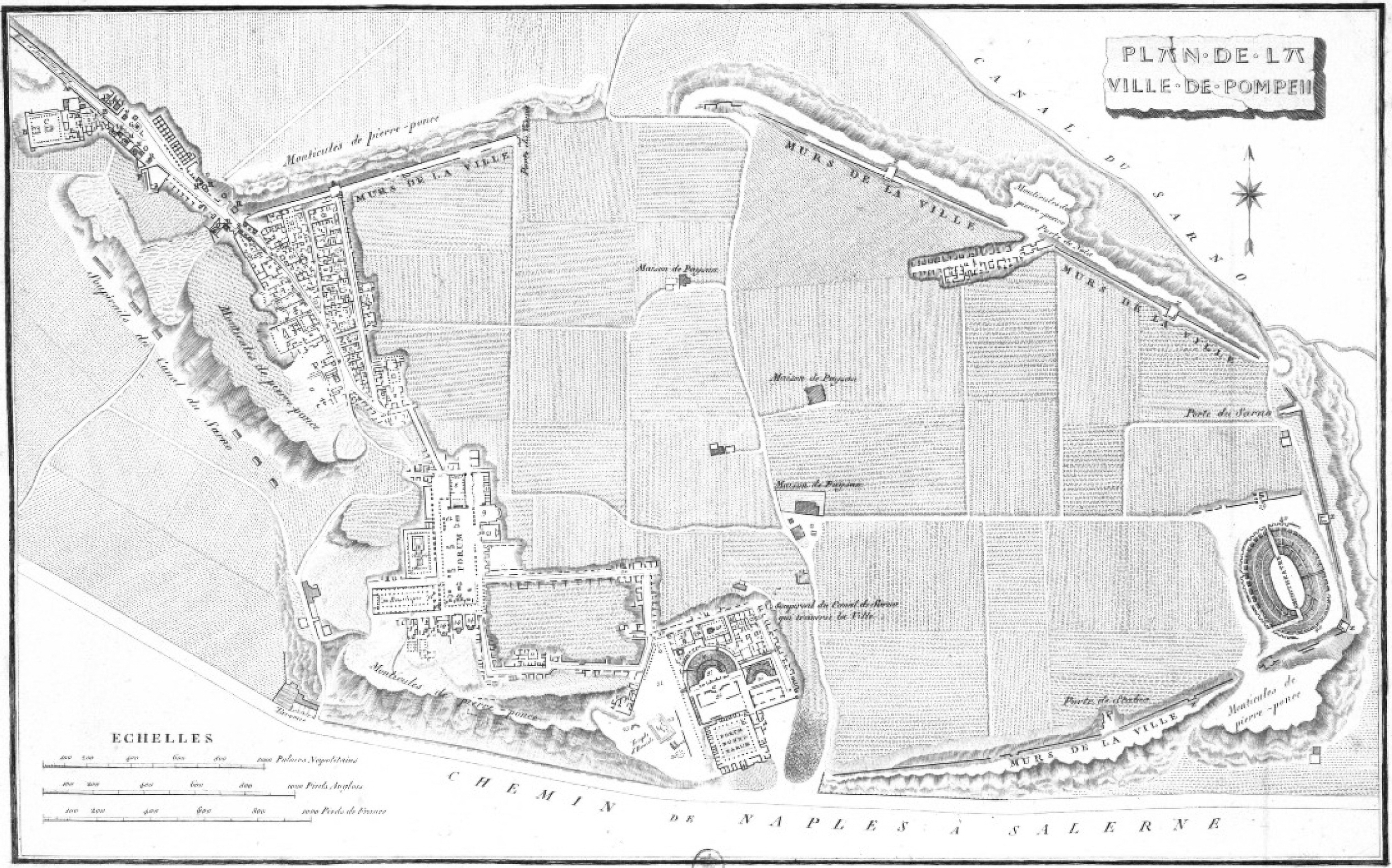
Pompeii 1812
Plan of Pompeii in 1812 by Mazois. Published in Mazois F., 1824. Les Ruines de Pompei: Premiere Partie. Paris: Firmin Didot. pl. III.

Pompeii 1815
Plan of Pompeii in 1815 by I G Russo.
Photo courtesy of Wien Nationalbibliothek
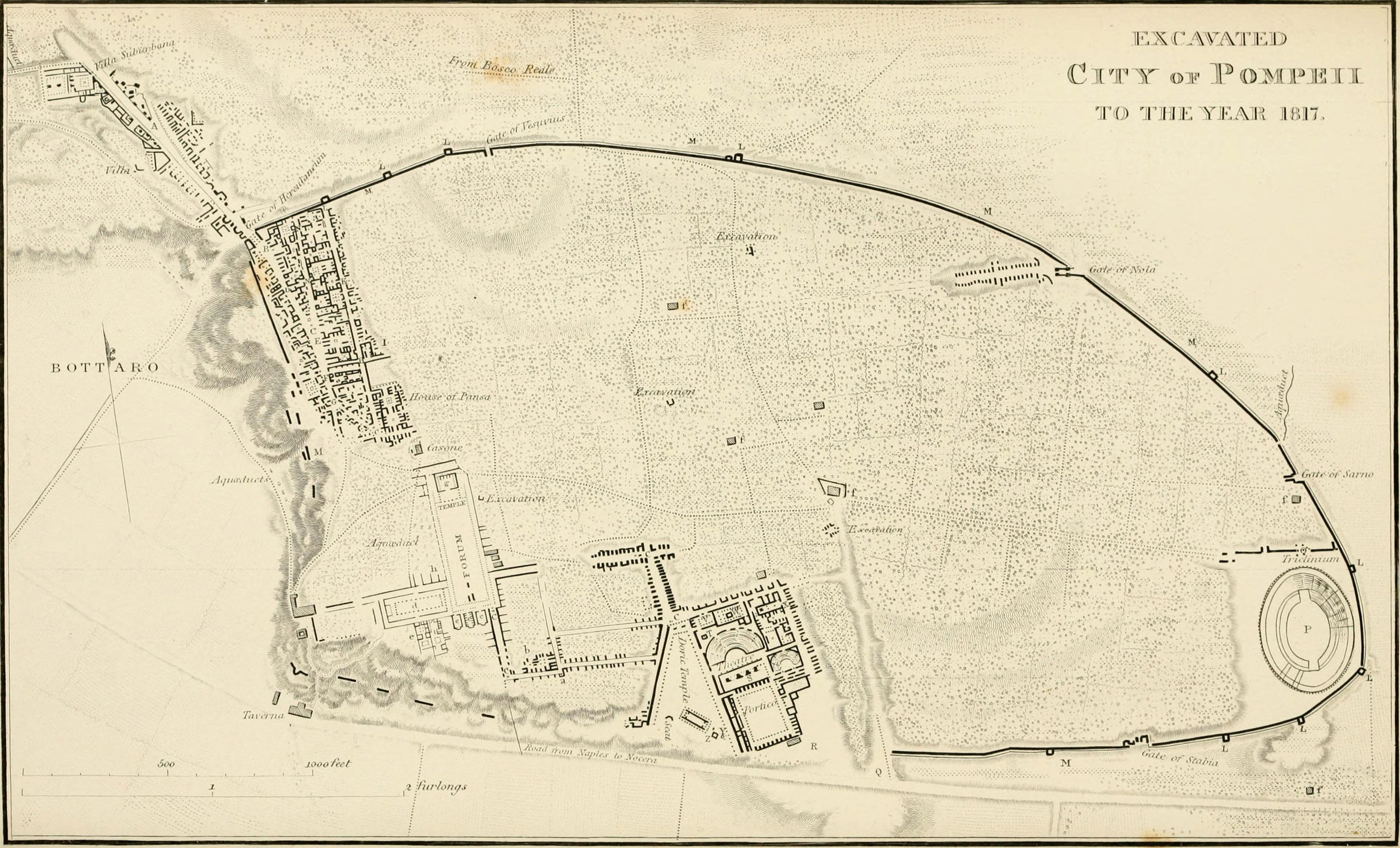
Pompeii 1817
Plan of Pompeii in 1817 published in Gell and Gandy, Pompeiana, 1819 plate 1.

Pompeii 1819
Plan of Pompeii 1819 showing excavations to that date. From Cooke Cockburn Donaldson, Pompeii, 1827 plate 2.

Pompeii 1819
Plan of Pompeii in 1819 by Muller.
Pompeii 1819
Plan of Pompeii in 1819 by H. Wilkins.

Pompeii 1817-1819
Hand painted plan from Pompeii published 1819 [Dessins publiés dans l'ouvrage de Sir William Gell et John P. Gandy, Pompeiana: the topography, edifices and ornaments of Pompei, 1817-1819], pl. 81. Bibliothèque de l'Institut National d'Histoire de l'Art [France]

Pompeii 1819
Left part of plan from Gell, W. Pompeii unpublished [Dessins de l'édition de 1832 donnant le résultat des fouilles post 1819 (?)] vol II, pl. 43 verso. Bibliothèque de l'Institut National d'Histoire de l'Art.

Pompeii 1819
Right part of plan from Gell, W. Pompeii unpublished [Dessins de l'édition de 1832 donnant le résultat des fouilles post 1819 (?)] vol II, pl. 43 recto. Bibliothèque de l'Institut National d'Histoire de l'Art.

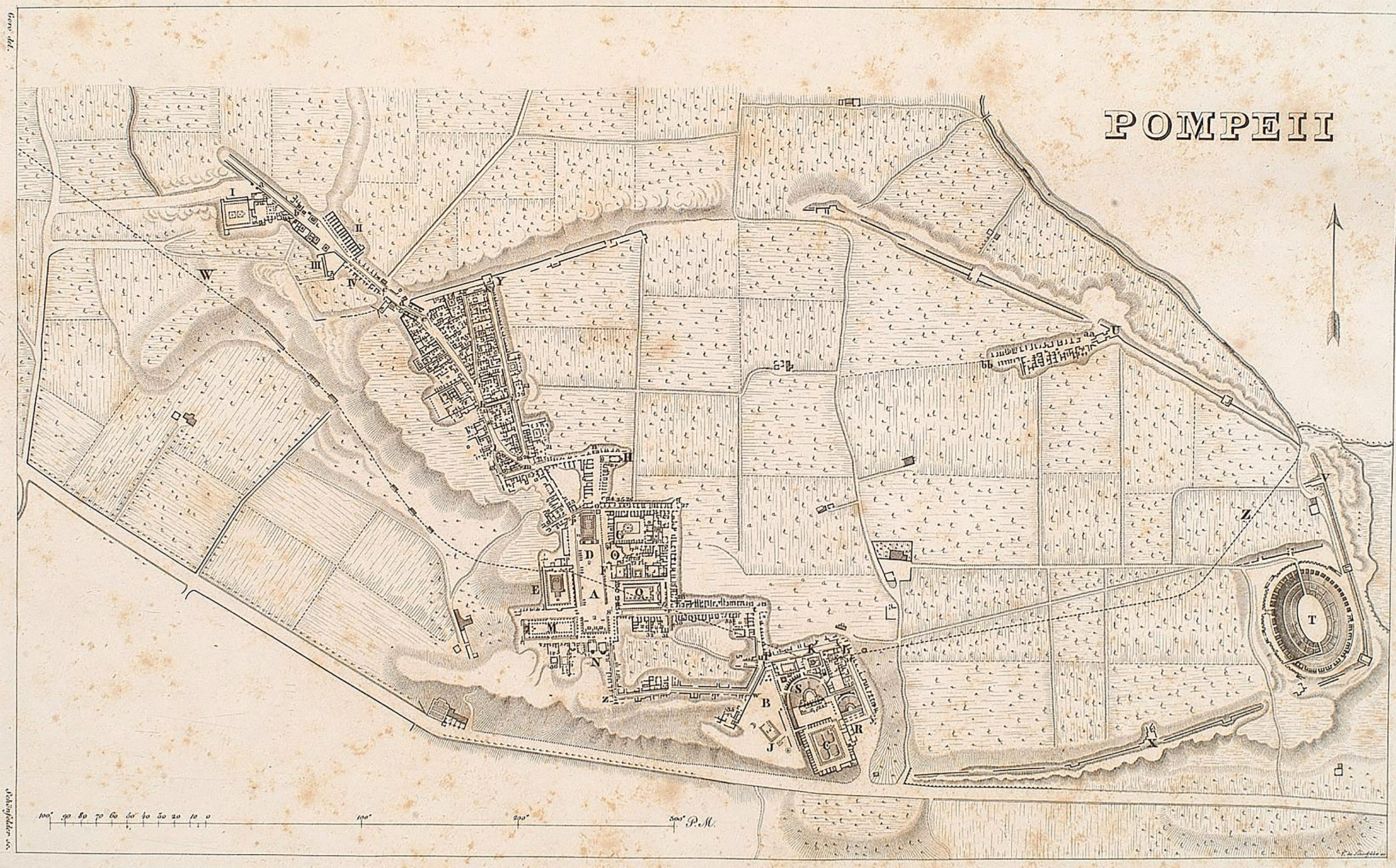
Pompeii 1820
Fold out plan produced in 1820 by George Glass of Naples.
Photo courtesy of Gallica.bnf.fr.

Pompeii 1822
Plan by M. J. Le Riche from Vues des monumens antiques de Naples 1827, pl. 13.
Pompeii 1825
Plan of Pompeii in 1825 by Agyagfalva.

Pompeii 1825
1825 plan by A. Bibent.
Photo courtesy of Gallica.bnf.fr.
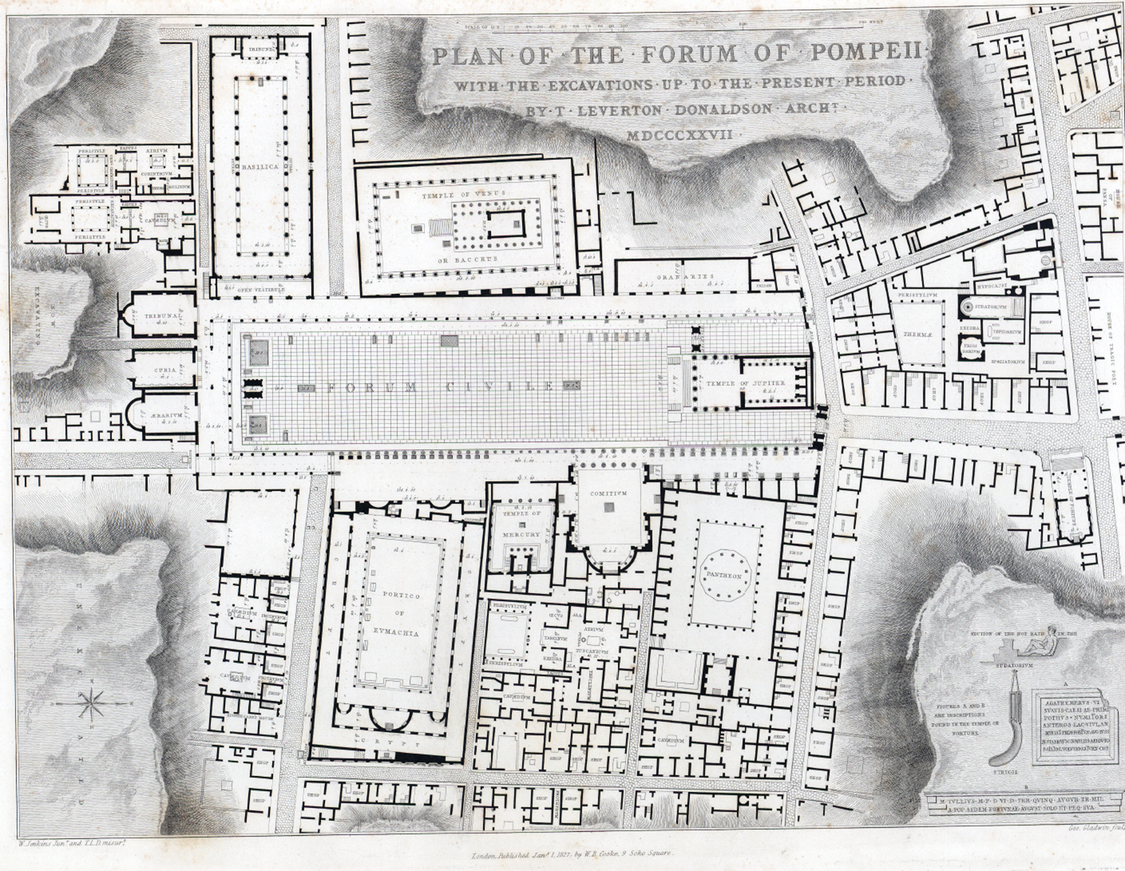
Pompeii Forum 1825
Plan of Pompeii Forum excavations to 1825. Cooke Coburn and Donaldson, Pompeii, 1827, part 1, plate 20.

Pompeii 1825
Plan of Pompeii in 1825 by A. de Jorio.
Photo courtesy of Gallica.bnf.fr.

Pompeii Theatres and Triangular Forum 1825
Plan of Pompeii Theatres and Triangular Forum excavations to 1825. Cooke Coburn and Donaldson, Pompeii, 1827, part 1, plate 14.

Pompeii 1826
Plan of Pompeii in 1826 by A. Bibent. From Cooke, Cockburn, Donaldson, Pompeii, 1827 part 1, plate 3.

Pompeii 1826
Plan of Pompeii in 1826 by Cuciniello and Bianco.

Pompeii 1827
Plan of Pompeii in 1827 by P. Fumagalli, published in 1876.

Pompeii 1827
Plan of Pompeii in 1827 by G. Marchese.
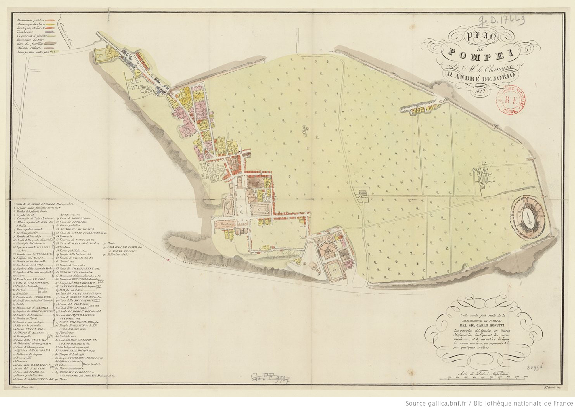
Pompeii 1827
Plan of Pompeii in 1827 by A. de Jorio.
Photo courtesy of Gallica.bnf.fr.

Pompeii 1828
Plan of Pompeii in 1828 by Zahn.

Pompeii 1828
Plan of Pompeii published in 1828 in Views of Pompeii drawn on stone, by J D Harding, after drawings by William Light.

Pompeii 1829
Plan of Pompeii in 1829 by A. de Jorio.
Photo courtesy of Gallica.bnf.fr.

Pompeii 1830
Plan of Pompeii in 1830 by Fumagalli.
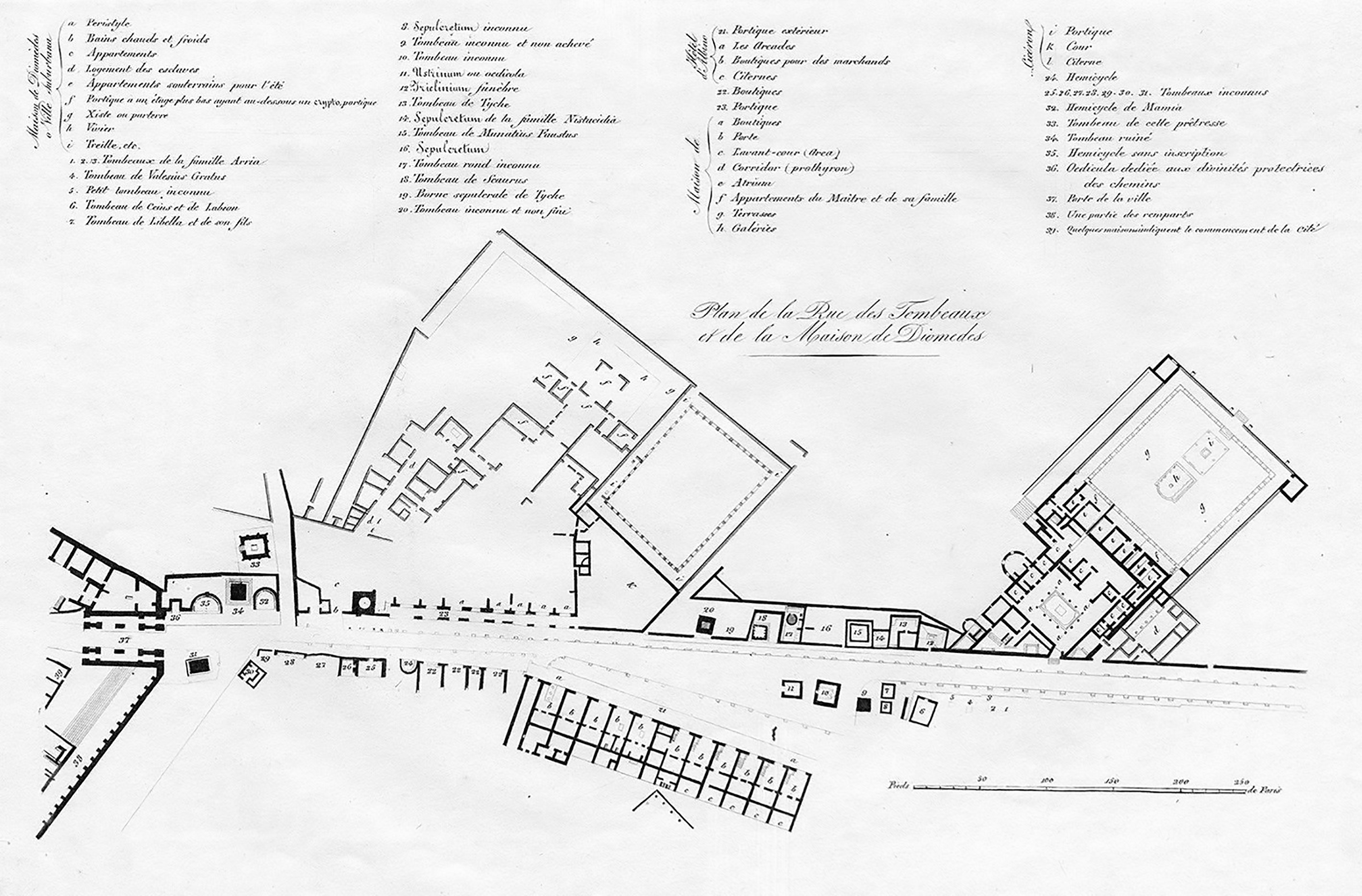
Pompeii 1830 Via dei Sepolcri
Plan of the Street of Tombs, Villa of Diomedes and Cicero in Pompeii in 1830 by Fumagalli.

Pompeii 1831
Plan of Pompeii in 1831 by A. de Jorio.
Photo courtesy of Gallica.bnf.fr.

Pompeii 1831
Plan of Pompeii in 1831 by L. Rossini.
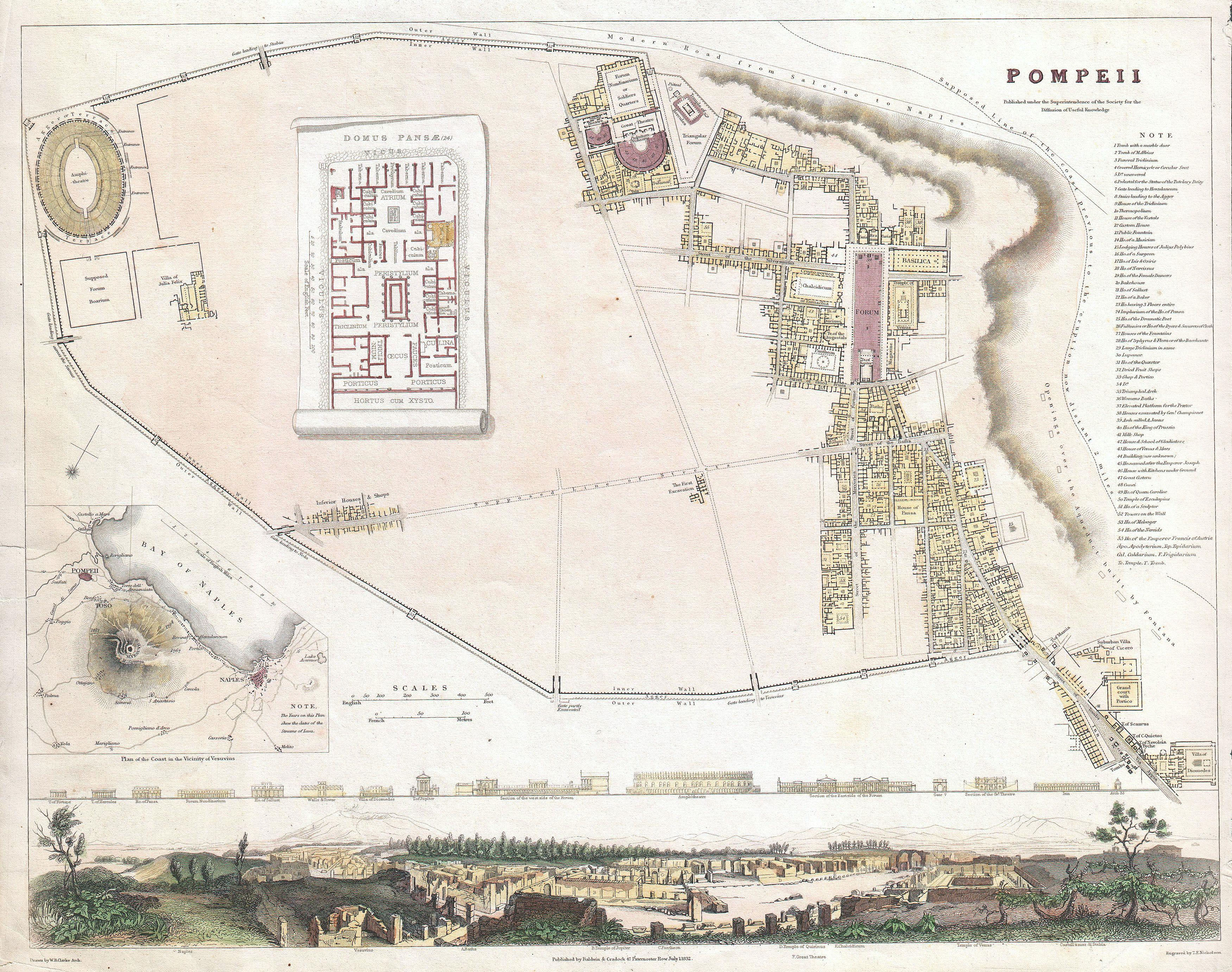
Pompeii 1832
Plan of Pompeii in 1832 by Baldwin and Cradock for the Society for the Diffusion of Useful Knowledge. From Wikimedia.

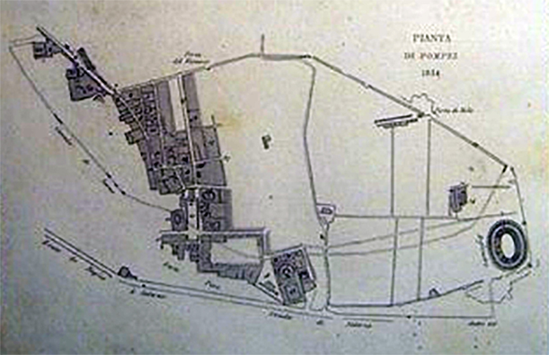
Pompeii 1833
Plan of Pompeii in 1833 by Giosuè Russo, with the different colouring of the progress of the excavations marked.
Pompeii 1834
Plan of Pompeii in 1834, published by Auton in 1837.

Pompeii 1839
Plan Pompeii in 1839 by Ferdinando Artaria.

Pompeii 1839
Plan of Pompeii in 1839 by A. de Jorio.

Pompeii 1830s or early 1840s
Plan of Pompeii by F. Neymiller. Published in Zucoli L., Ed., 1844. Nuovissima Guida dei viaggiatori in Italia e nelle principali parti d'Europa, 2nd Ed. p. 271.

Pompeii 1841
Plan of Pompeii in 1841 by Ferdinando Artaria.

Pompeii 1843
Plan of Pompeii in 1843 by De Sanctis

Pompeii 1843
Plan of Pompeii in 1843 by J. Engelhard.

Pompeii 1843 or 1845
1843 or 1845 plan of Pompeii, (the date is unclear on the plan).
Photo courtesy of Gallica.bnf.fr.

Pompeii 1845
Plan of Pompeii in 1845 by Bonucci.
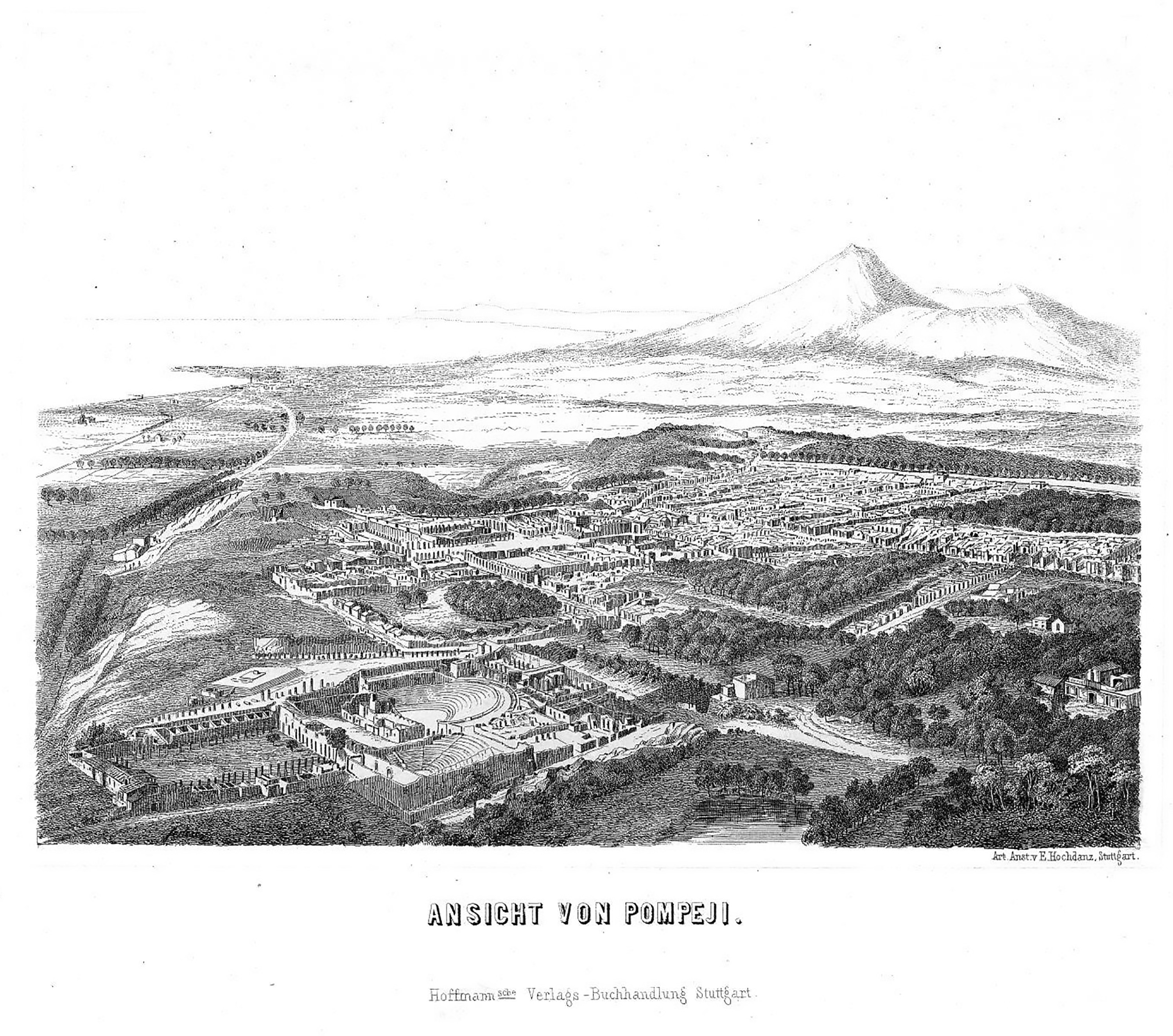
Ansicht von Pompeji 1848
A birds eye view of Pompeii in a lithograph dated 1848 by Emil Hochdanz. Possibly based on a balloon flight. It shows the old spur and approach to Pompeii near the Forum and Porta Marina. You can also see the original train line running along to the left. Photo courtesy of Rick Bauer.

Pompeii 1848
Plan of Pompeii in 1848 by Bonucci.
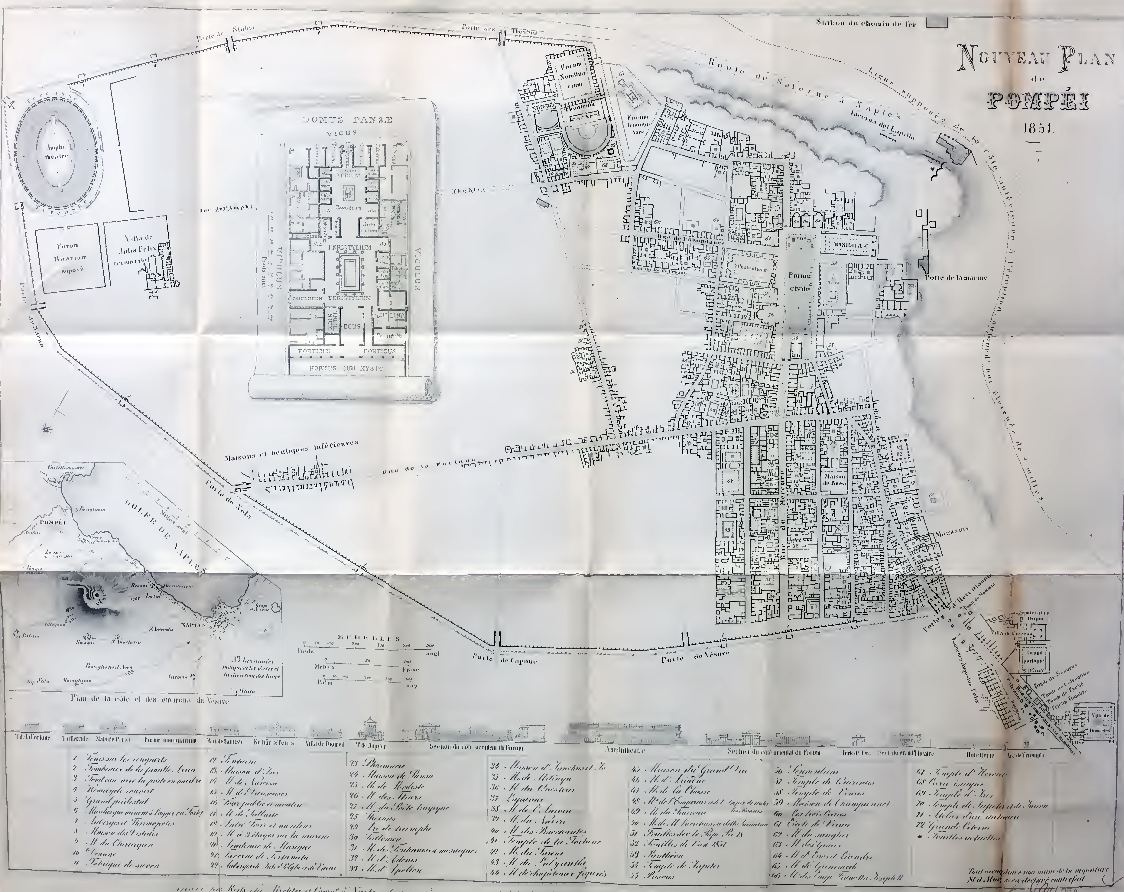
Pompeii 1851
Plan of Pompeii in 1851 by D'Aloe S., 1851. Les Ruines de Pompei.

Pompeii 1852
Plan of Pompeii showing excavations from 1748 to 1844. Published by Zahn in 1852.

Pompeii 1855
Plan of Pompeii excavations from 1754-1855 by J. G. Bach. Published by Overbeck in 1855.
Pompeii 1856
Plan of Pompeii in 1856, d-apres les dernieres fouilles, by A. H. Dufour.

Pompeis 1859
Fiorelli and Sorgente produced a plan of Pompei in 1859.
Tabula coloniae Veneriae Corneliae Pompeis consists of 42 plates.
You can browse this plan in detail on Fortuna Visiva
http://pompei.sns.it/
Our summary plan is from 1861, courtesy of Gallica.bnf.fr.

Pompeii 1859
Plan of Pompeii in 1859, d-apres les dernieres fouilles, by A. H. Dufour.

Pompeii 1860
Nuovo pianta degli scavi di Pompei 1860. Photo courtesy of Gallica.bnf.fr.

Pompeii 1860
Plan of Pompeii in 1860.

Pompeii 1863
Plan of Pompeii in 1863, d-apres les dernieres fouilles, by A. H. Dufour.
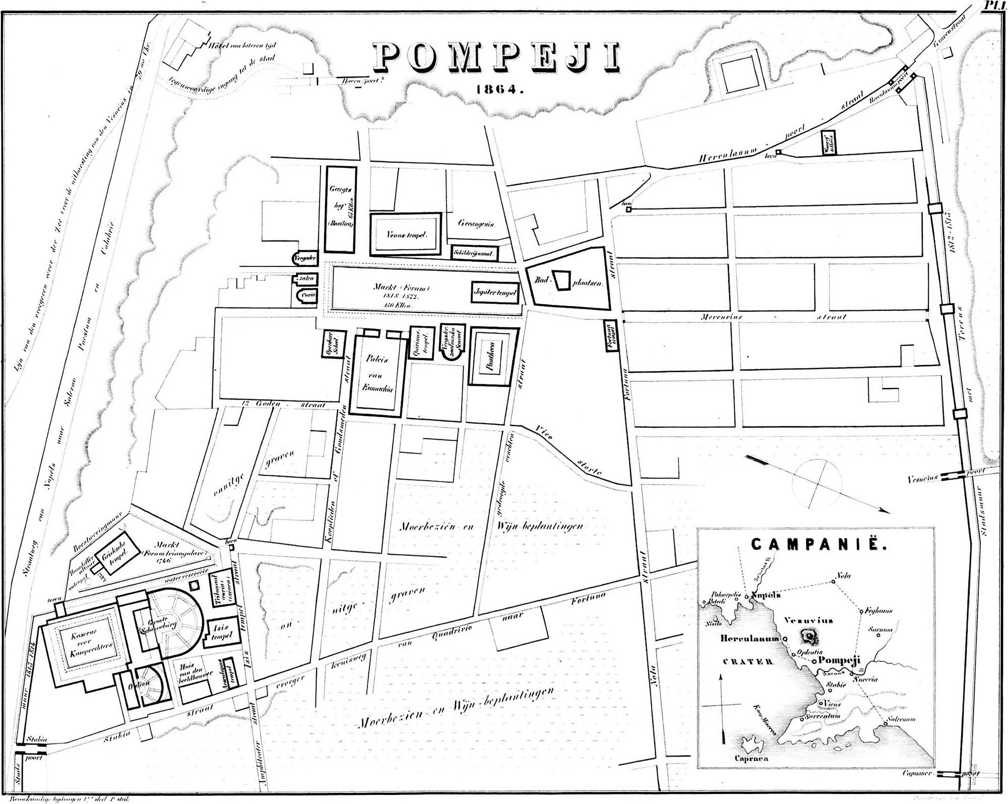
Pompeii 1864
Dutch Plan of Pompeii in 1864 by J. J. C. de Wijs. Published in Bouwkundige Bijdragen, Deel 17, 1870. Photo Wikimedia.

Pompeii 1865
Plan of Pompeii in 1865 from Karl von Spruner’s 1865 rendering of Southern Italy and Sicily in antiquity. Photo Wikimedia.
Pompeii 1865
Plan of Pompeii in 1865 by Wagner.
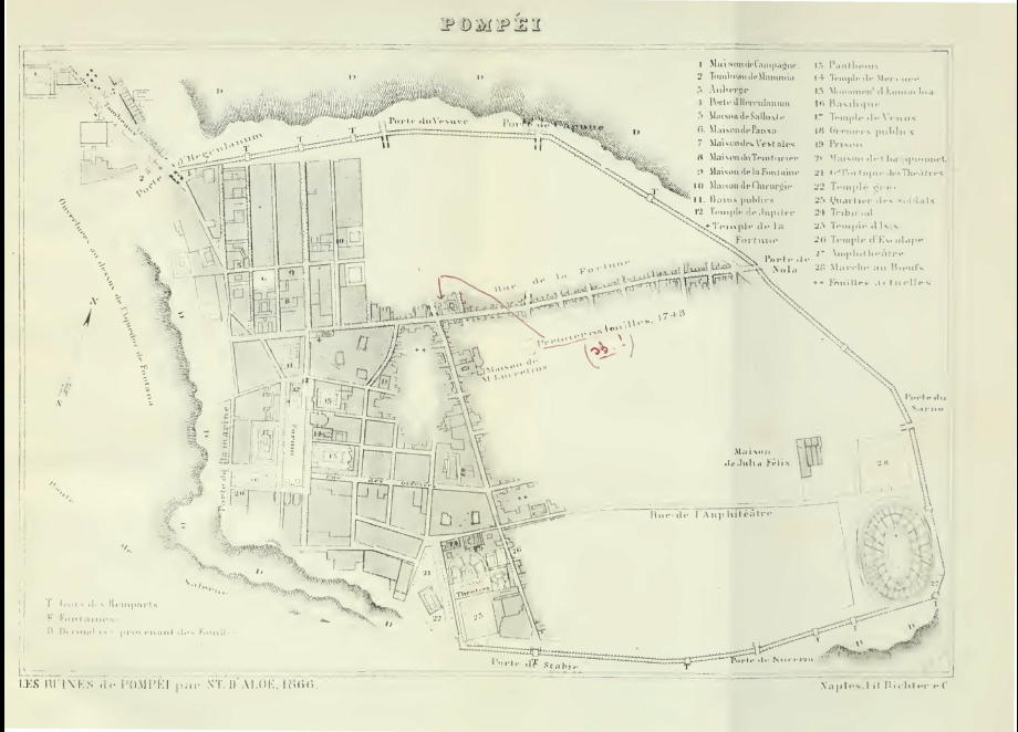
Pompeii 1866
Plan of Pompeii in 1866 by D'Aloe.

Pompeii 1867
Plan of Pompeii in 1867 from C. I. L. IV, volume 1.
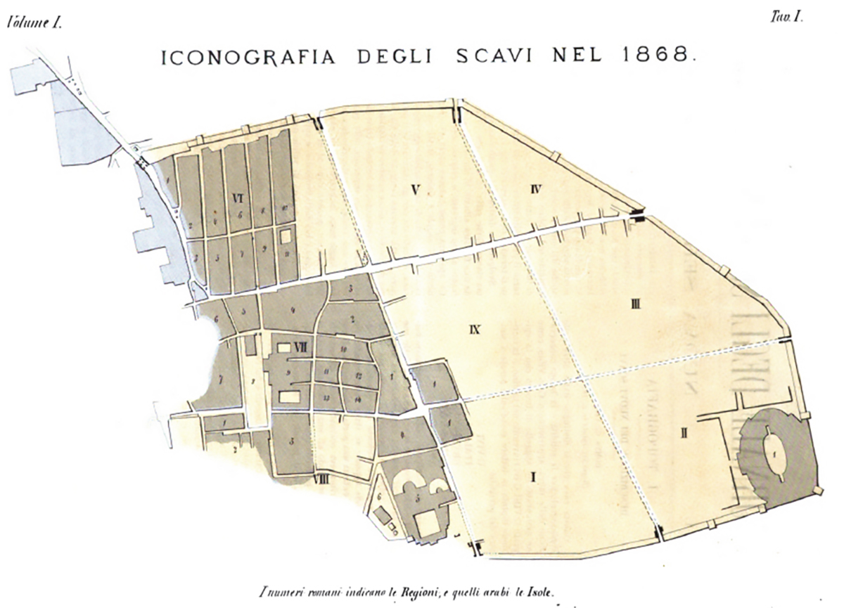
Pompeii 1868
Plan of Pompeii 1868 by Fiorelli. Giornale degli scavi, NS1, 1868, Tav. 1.

Pompeii 1868
Plan of Pompeii 1868 from Murray Guide.
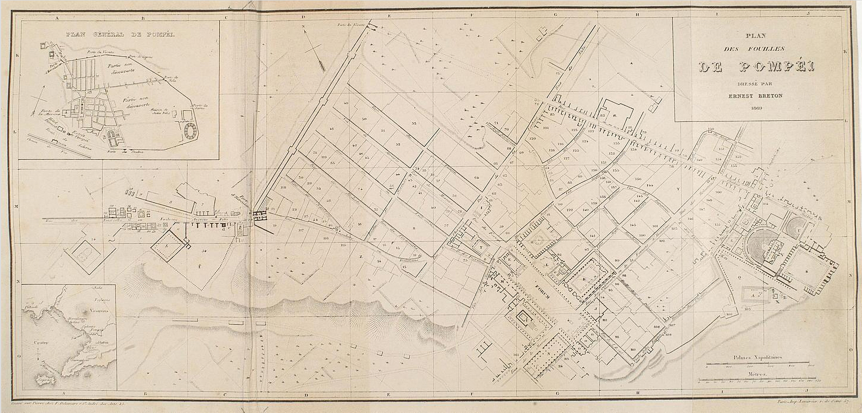
Pompeii 1869
Plan of Pompeii in 1869 by E. Breton.

Pompeii 1869
Plan of Pompeii in 1869, d-apres les dernieres fouilles, by A. H. Dufour.

Pompeii 1870
Nuovo pianta degli scavi di Pompei, 1870. Photo courtesy of Gallica.bnf.fr.

Pompeii 1870's
Plan from Baedeckers handbook c. 1870's. Courtesy of Rick Bauer.

Pompeii 1871
Plan of Pompeii in 1871 by Ferdinando Artaria.

Pompeii 1871
Plan of Pompeii in 1871 by Dyer, showing the excavated portion reduced from Fiorelli. Photo courtesy of Rick Bauer.
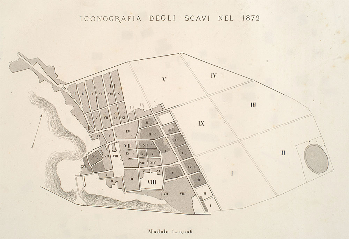
Pompeii 1872
Plan of Pompeii in 1872 by Fiorelli. From Gli scavi di Pompei dal 1861 al 1872, tav. 1.

Pompeii 1872
Plan from Harper's Hand-Book of c. 1870's, possibly 1872 Courtesy of Rick Bauer.

Pompeii 1872
Gesamtplan der Stadt Pompeji mit dem Ergebnis der Ausgrabungen bis 1872.
Overall plan of the city of Pompeii with the result of the excavations until 1872.
See Overbeck J. Pompeji in seinen Gebauden Alterthumen und Kunstwerken 1875.

Pompeii 1872
Plan of Pompeii from Harper's Handbook, 1872.

Pompeji 1875
Plan der ausgegrabenen Theile Pompejis zur Übersicht der Hauptbauperioden und der Nivellirung 1875.
Plan of the excavated parts of Pompeii with overview of the main building periods and the levels 1875.
See Overbeck J. Pompeji in seinen Gebauden Alterthumen und Kunstwerken 1875.

Pompeii 1876
Nouveau Plan de Pompei by Scafati. French language version of the plan of Pompeii as in 1876.
Photo courtesy of Rick Bauer.

Pompeii 1877
Plan of Pompeii in 1877 by E. Presuhn.

Pompeii 1878
Plan of Pompeii showing excavations up to 1878.

Pompeii 1878
Plan of Pompeii in 1878 by E. Presuhn. Shows excavations from 1874 to 1878.

Pompeii 1879
Plan with Stabiae, Pompeii and Bay of Naples by G. Tascone. Published in Ruggiero M, Pompei e la Regione sotterato nel Vesuvio nell'anno LXXIX, 1879.

Pompeii 1881
Plan of Pompeii in 1881 by E. Presuhn.
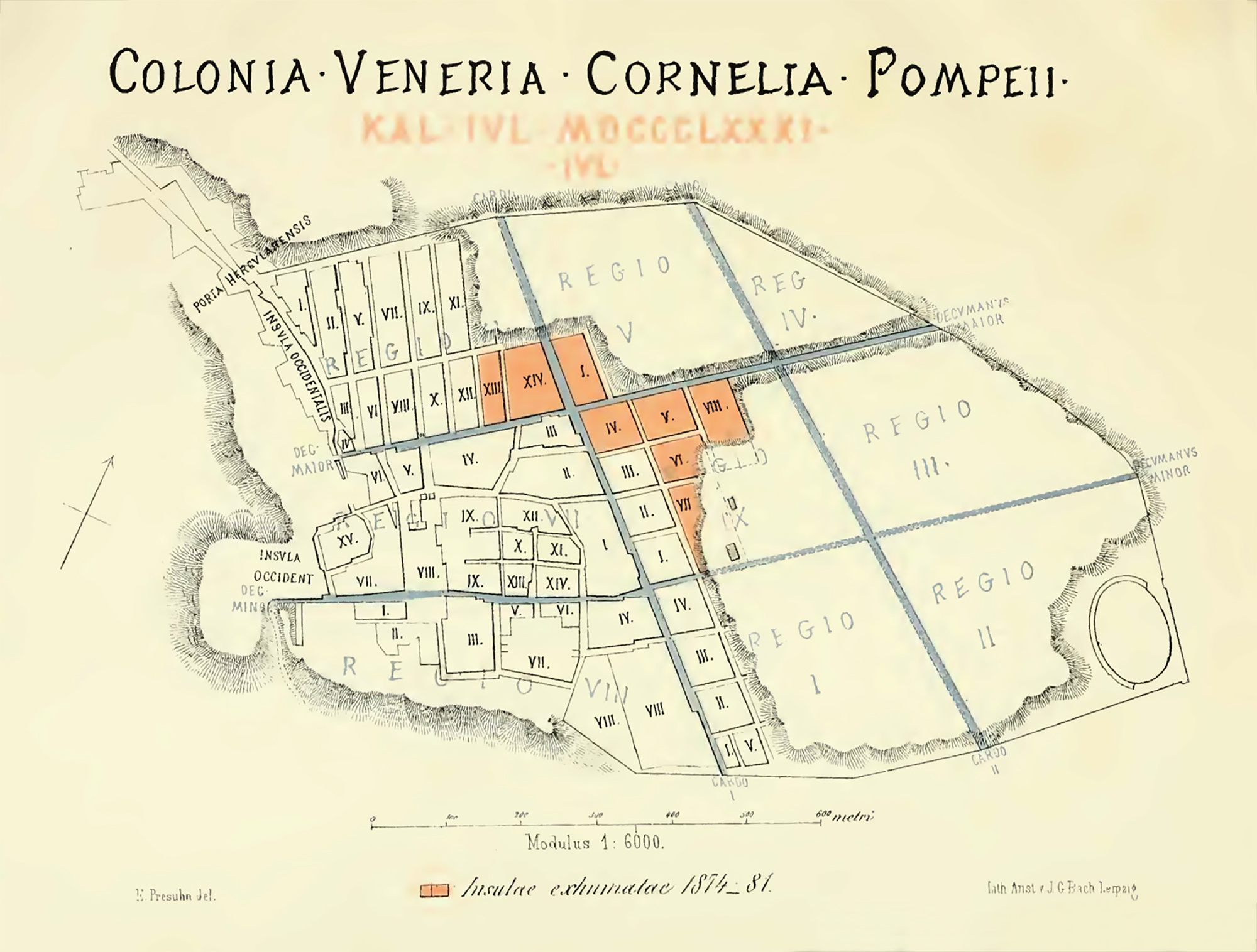
Pompeii 1882
Map of Pompeii published by E. Presuhn in 1882. Shows the excavations from 1874 to 1881.

Pompeii 1882
Gesamtplan der Stadt Pompeji mit dem Ergebnis der Ausgrabungen bis 1882.
Overall plan of the city of Pompeii with the result of the excavations until 1882.
See Overbeck J. und Mau A. Pompeji in seinen Gebauden Alterthumen und Kunstwerken 1884.

Pompeii 1887
Plan of Pompeii in 1887 from Murano D., 1894. Pompei donde venivano le acque potabili ai castelli acquarii.
Pompeii 1888
Plan of Pompeii published in Rolfe E. N., 1888. Pompeii Popular and Practical.

Pompeii 1888
Plan of Pompeii in 1888 published in Meyers Konversationlexikon. Photo Wikimedia.
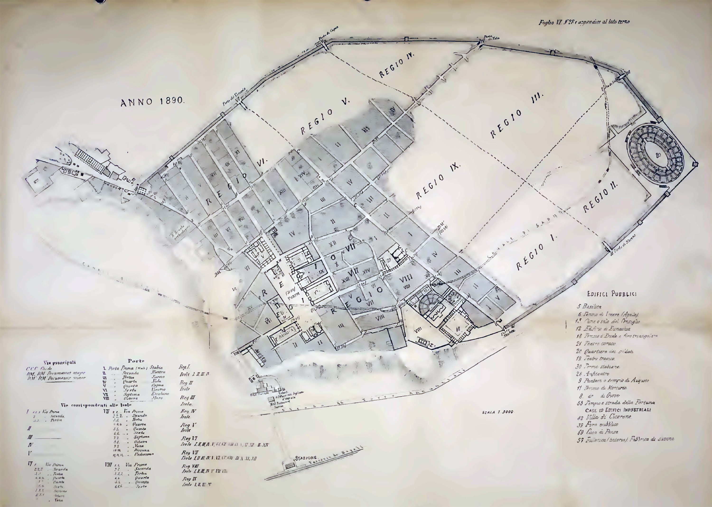
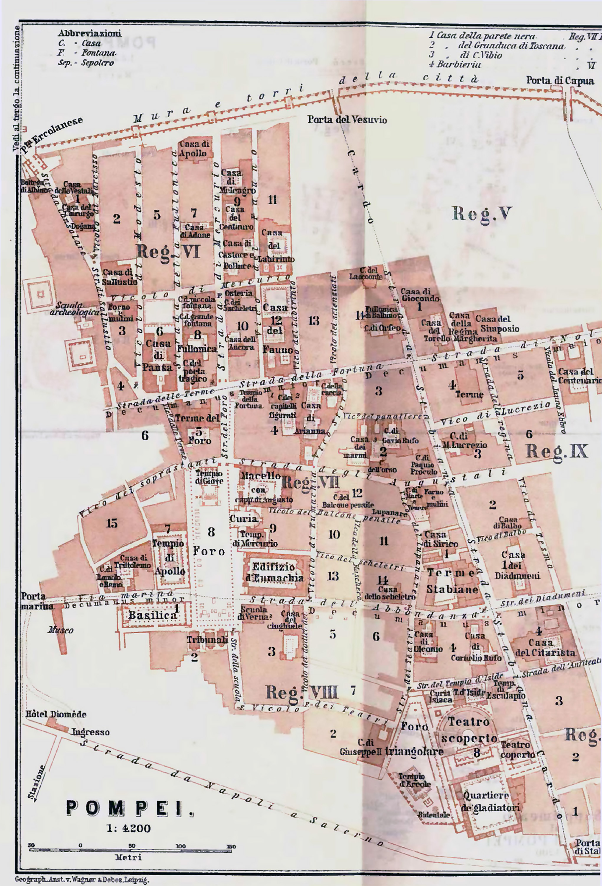
Pompeii 1890
Plan of Pompeii in 1890 from Murano D., 1894. Pompei donde venivano le acque potabili ai castelli acquarii.
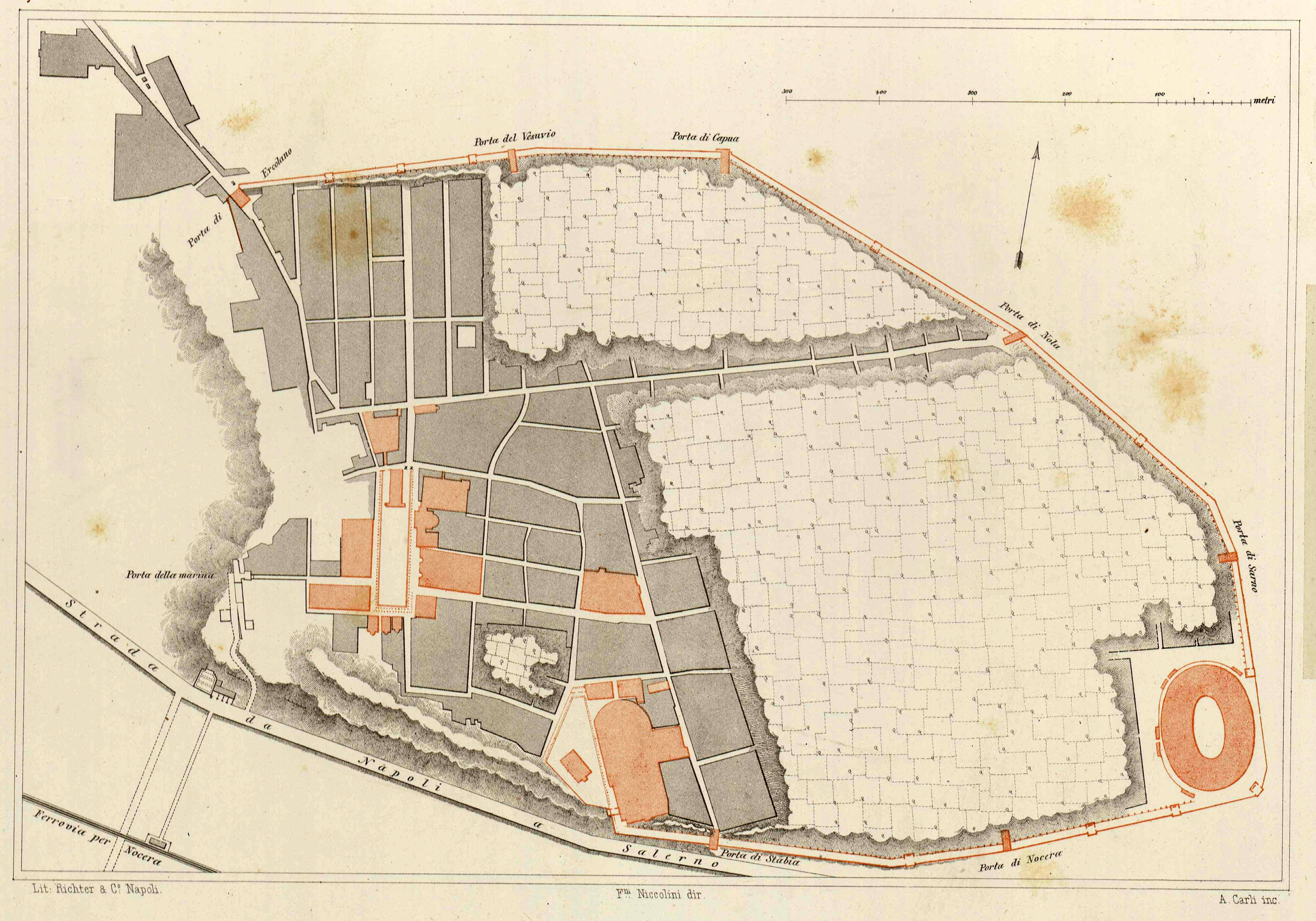
Pompeii 1890
Plan of Pompeii published in 1890 in Niccolini F, 1890, Le case ed i monumenti di Pompei, Vol. III, Topografia di Pompei, Tav II.

Pompeii 1893
Plan of Pompeii in 1893 by Baedecker.
Pompeii 1890s
Plan of Pompeii produced in 1890s.
Photo courtesy of Gallica.bnf.fr.
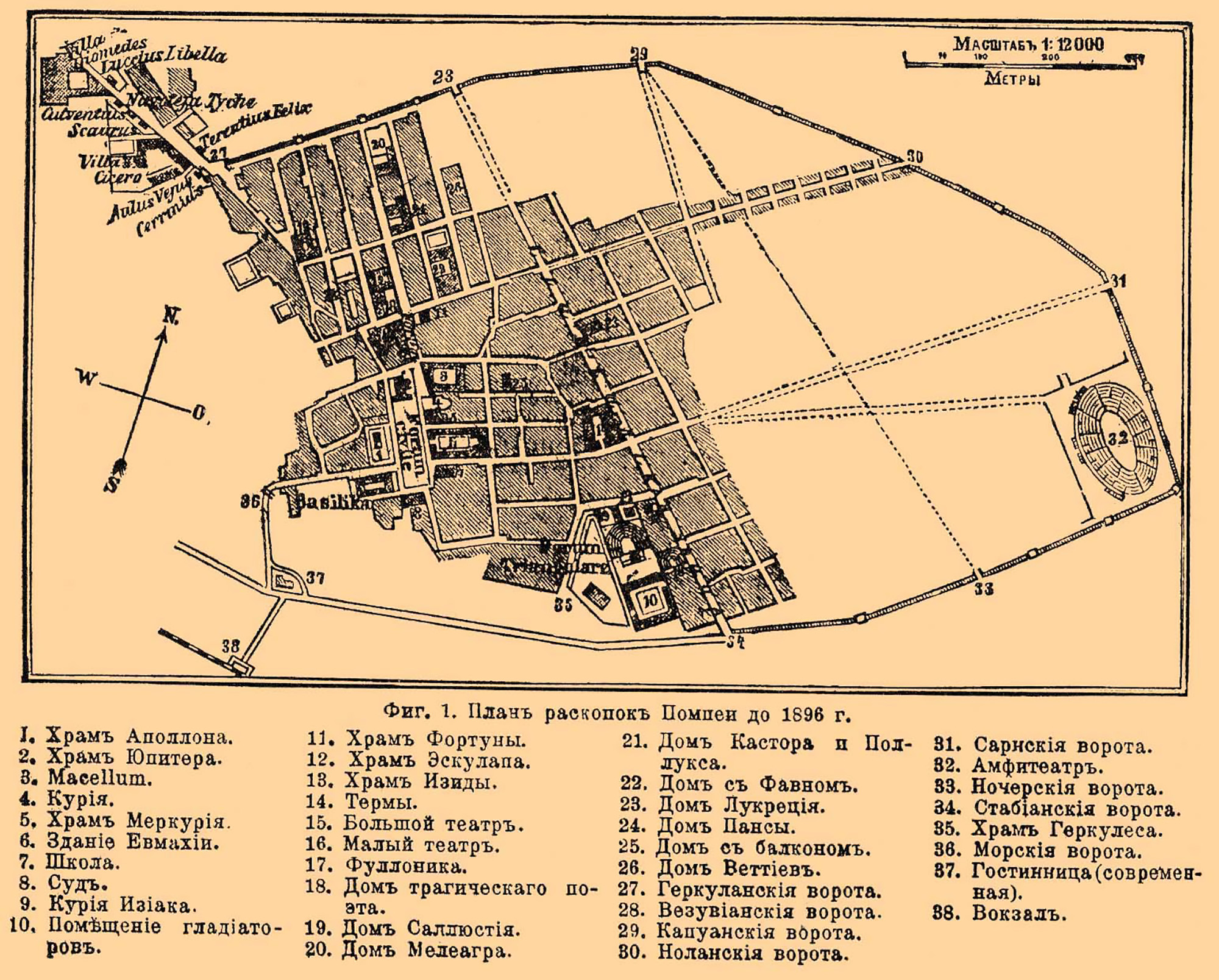
Pompeii 1896
Plan of Pompeii in 1896 published in Brockhaus and Efron Encyclopedic Dictionary. Photo Wikimedia.

Pompeii 1899
Plan of Pompeii published by Pierre Gusman in Pompei La Ville, Les Moeurs, Les Arts, 1899, p. 35.

Pompeii 1900
Plan of Pompeii in 1900 published by Baedeker.

Pompeii 1900
Detailed plan of the excavations published by Baedeker in 1900. A second plan supplement contained Porta Ercolano and Via dei Sepolcri, see below.

Pompeii 1900
Detailed plan of the excavations published by Baedeker in 1900. Supplement with Porta Ercolano and Via dei Sepolcri. It also contains a plan of the House of Pansa.

Pompeii 1900
Plan published in 1900 showing the canale di Sarno and routes over unexcavated areas. Courtesy of Rick Bauer.

Pompeii 1901
Plan of Pompeii published in Mau and Kelsey, Pompeii its Life and Art, 1901, plan 1.
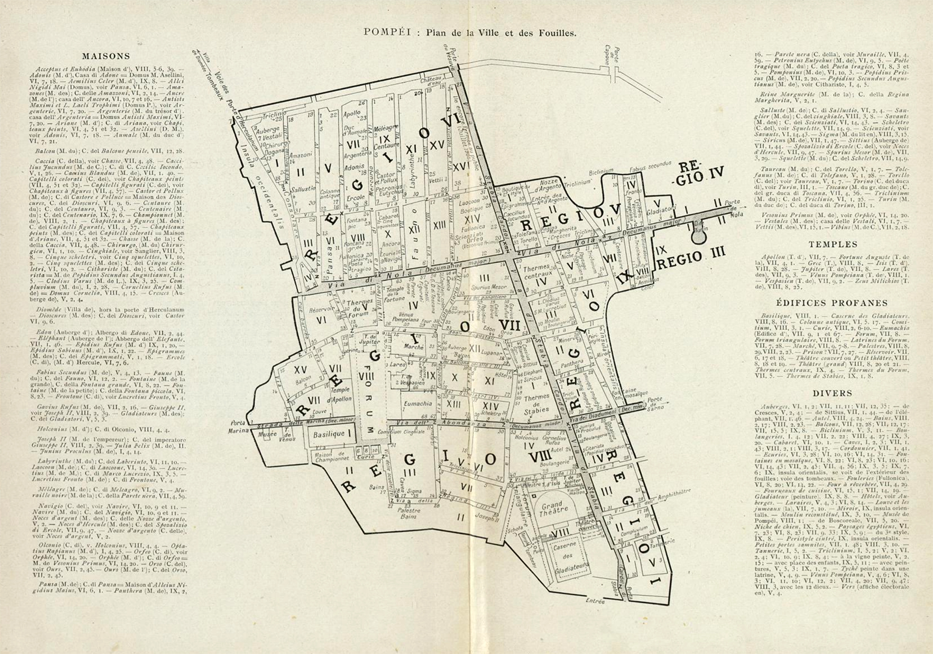
Pompeii 1906
Plan de la ville et des fouilles de Pompéi, publié par H. Thédenat, Pompéi Vie Privée, 1906.

Pompeii 1906
Plan of Pompeii in 1906 published in Meyers Konversationlexikon.

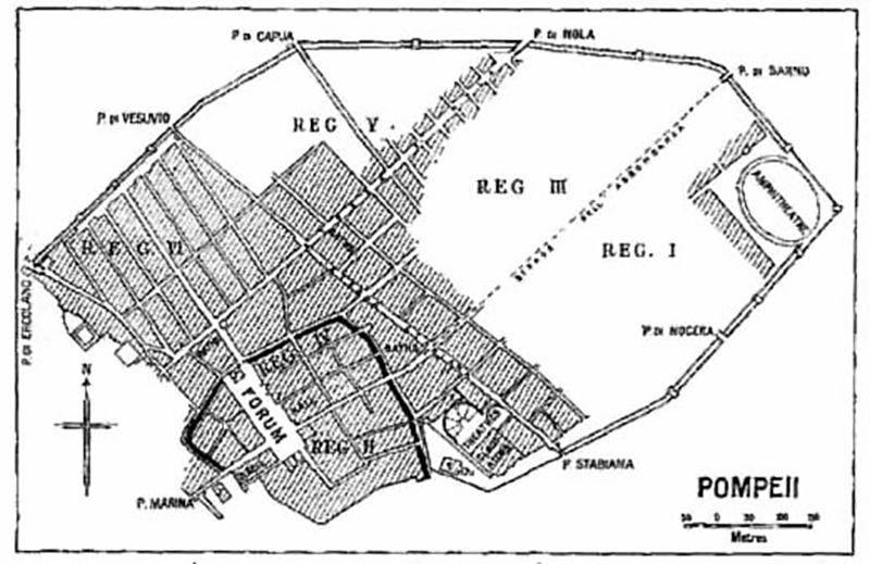
Pompeii 1907
Plan of Pompeii published in 1907 by Prof. Adolfo Cetto.
See Cetto, A. Pompei e il golfo di Napoli nell'antichità : (L'eruzione vesuviana del 79 d.C.
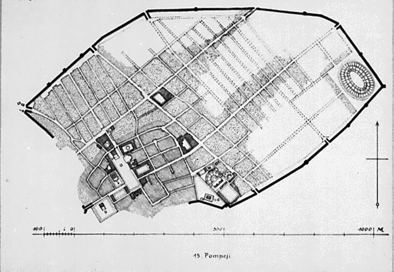
Pompeii 1910
Plan of Pompeii in 1910 after Mau. The original settlement is outlined in black. Photo Project Gutenberg, Ancient Town-Planning, by F. Haverfield, 1913, fig. 13.

Pompeii 1925
Plan of Pompeii in 1925 by Murray. It shows the Stazione di Pompei Scavi and Ristorante Svizzero outside the Porta di Nola. Courtesy of Rick Bauer

Pompeii 1928
Map of Pompeii by Baedecker, published in 1928. Courtesy of Rick Bauer.
Pompeii 1929
Plan Pompeii in 1929. Photo courtesy of Deutsches Archäologisches Institut. Inst neg 1929.633.

Pompeii 1930s to 1955?
Plan of Pompeii received by the Deutsches Archäologisches Institut in 1955. It is a photo by Tatiana Warsher W.399 and in the inventory record it says it is copy by her of an original by A von Gerkan? The handwriting is hard to decipher. It may relate to the 1930s or up to 1955.
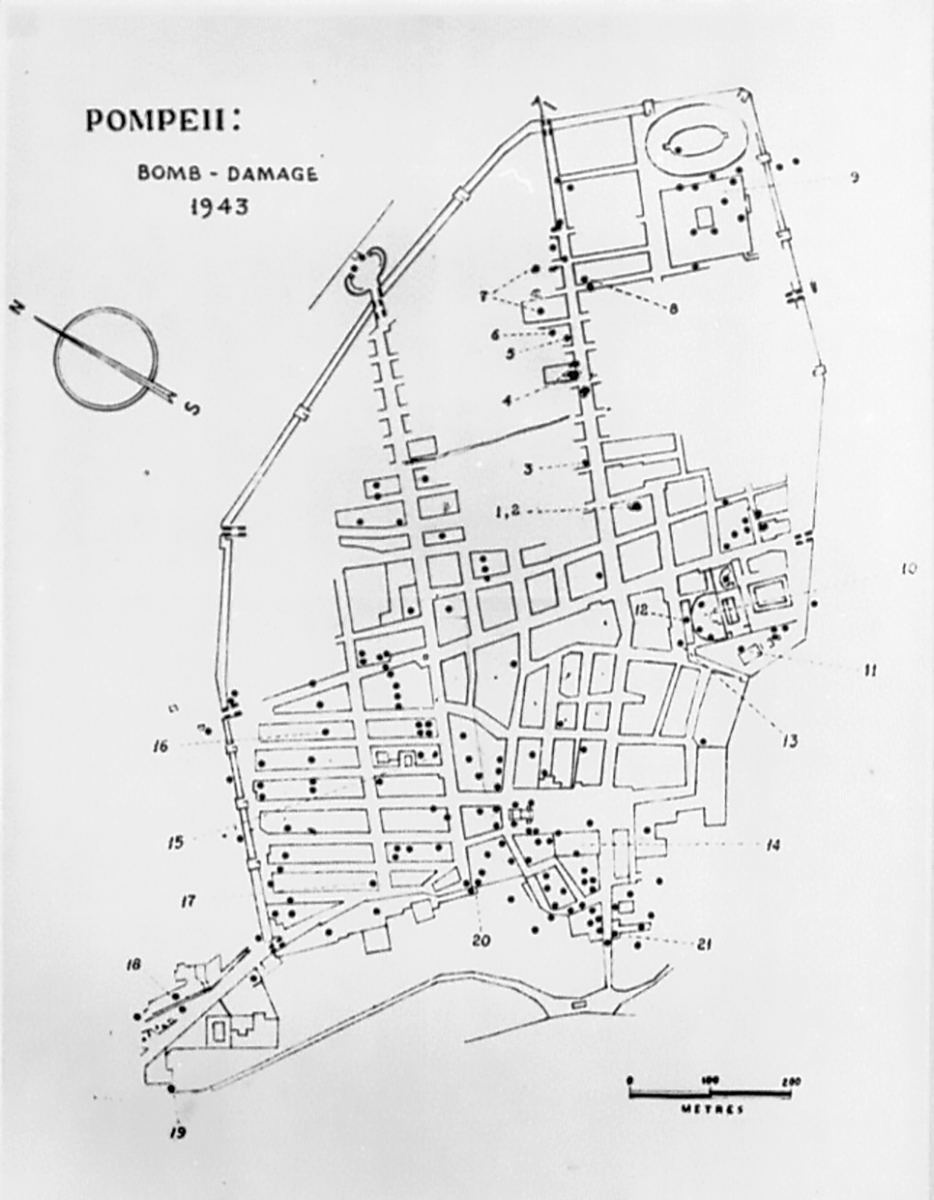
Pompeii 1943
Plan of Pompeii 1943 showing where bombs landed and bomb damage. Photo courtesy of Deutsches Archäologisches Institut. Inst.neg. 65.2004. See note 1 below.
.jpg)
Pompeii 1947
1947 plan of Pompeii entitled the FORMA VRBIS POMPEIORVM. This plan is cut onto a slab of travertine 5m wide by 2.73m high and was completed in 1947. It was installed in the Larario dei Pompeianisti located between the Porta Marina and the Antiquarium when the Larario was opened in 1948. It was updated on 31st December 1976. It can still be seen today as you enter or exit via the Porta Marina.
Photo courtesy of Michael Binns.
_0001%203.jpg)
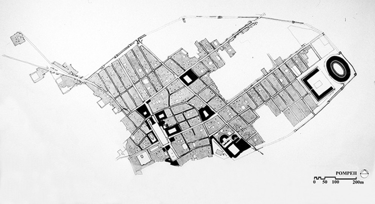
Pompeii 1951
1951 plan to illustrate the 5 year plan of Pompeian excavation.
The area in white is already excavated.
The shaded area is in the course of excavation.
The area in black is scheduled for excavation in the future.
Photo courtesy of Rick Bauer.

Pompeii 1955
Plan of Pompeii in 1955. Photo courtesy of Deutsches Archäologisches Institut. Inst. neg. 55.54 55.65.

Pompeii 1955
1955 plan of Pompeii showing old city and contours. Photo courtesy of Deutsches Archäologisches Institut. Inst. neg. 55.53 55.64.

Pompeii 1969
CTP plan of Pompeii in 1969. Photo courtesy of Deutsches Archäologisches Institut. Inst. neg. 69.842.

Pompeii 1983
Timeline map of the excavations in Pompeii up to and after 1983. Photo Wikimedia.
Pompeii 1998
Plan of Pompeii in 1998. Photo courtesy of University of Virginia.

Pompeii 2007
Plan of Pompeii in 2007 showing all Pompeii building entrances. Photo Courtesy of John Dobbins and Pedar Foss, World of Pompeii, DVD.

Pompeii 2007
Plan of Pompeii streets in 2007. Photo Courtesy of John Dobbins and Pedar Foss, World of Pompeii, DVD.
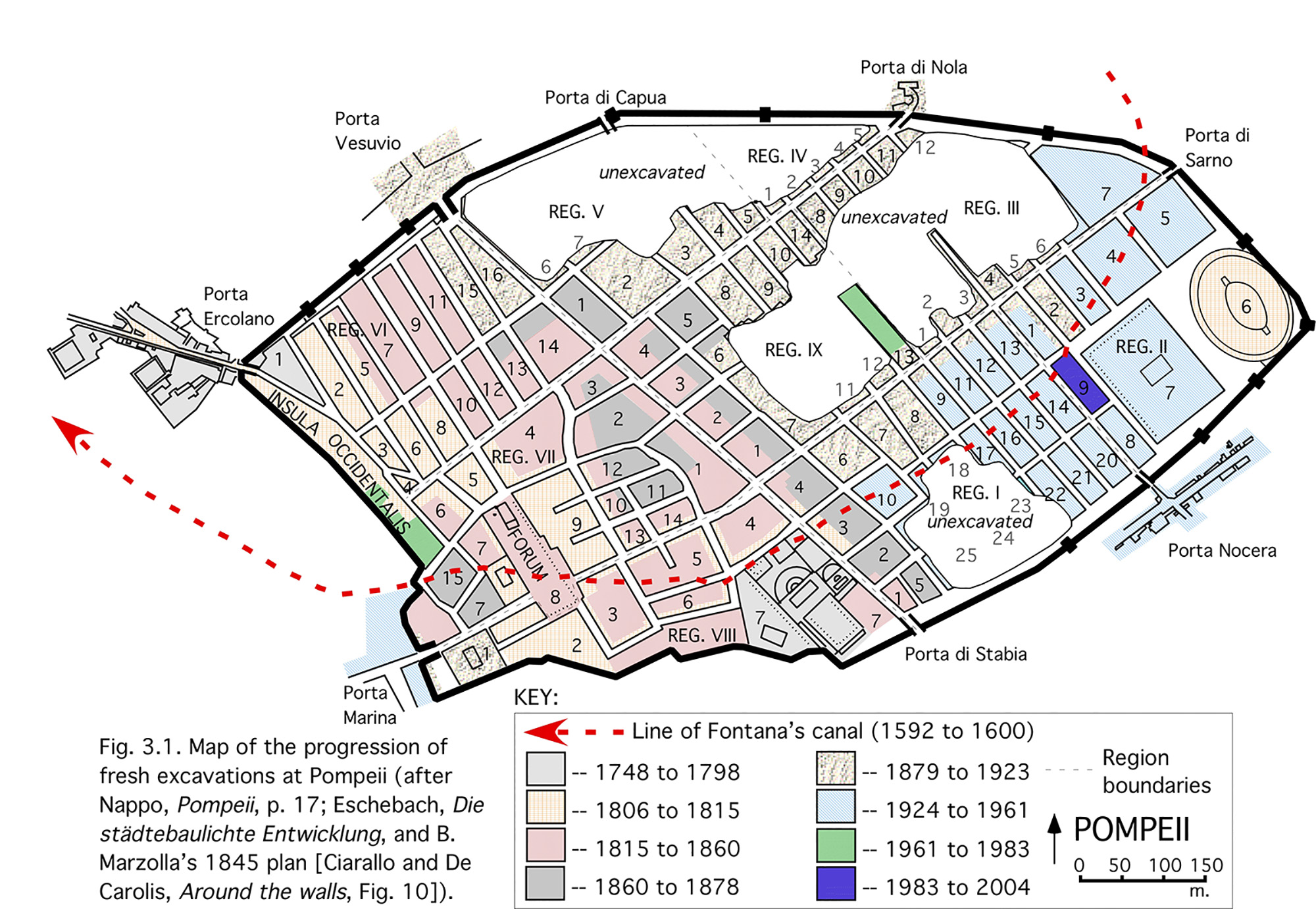
Pompeii 2007
Timeline plan of Pompeii excavations to 2007. Photo Courtesy of John Dobbins and Pedar Foss, World of Pompeii, DVD, Fig3-1.
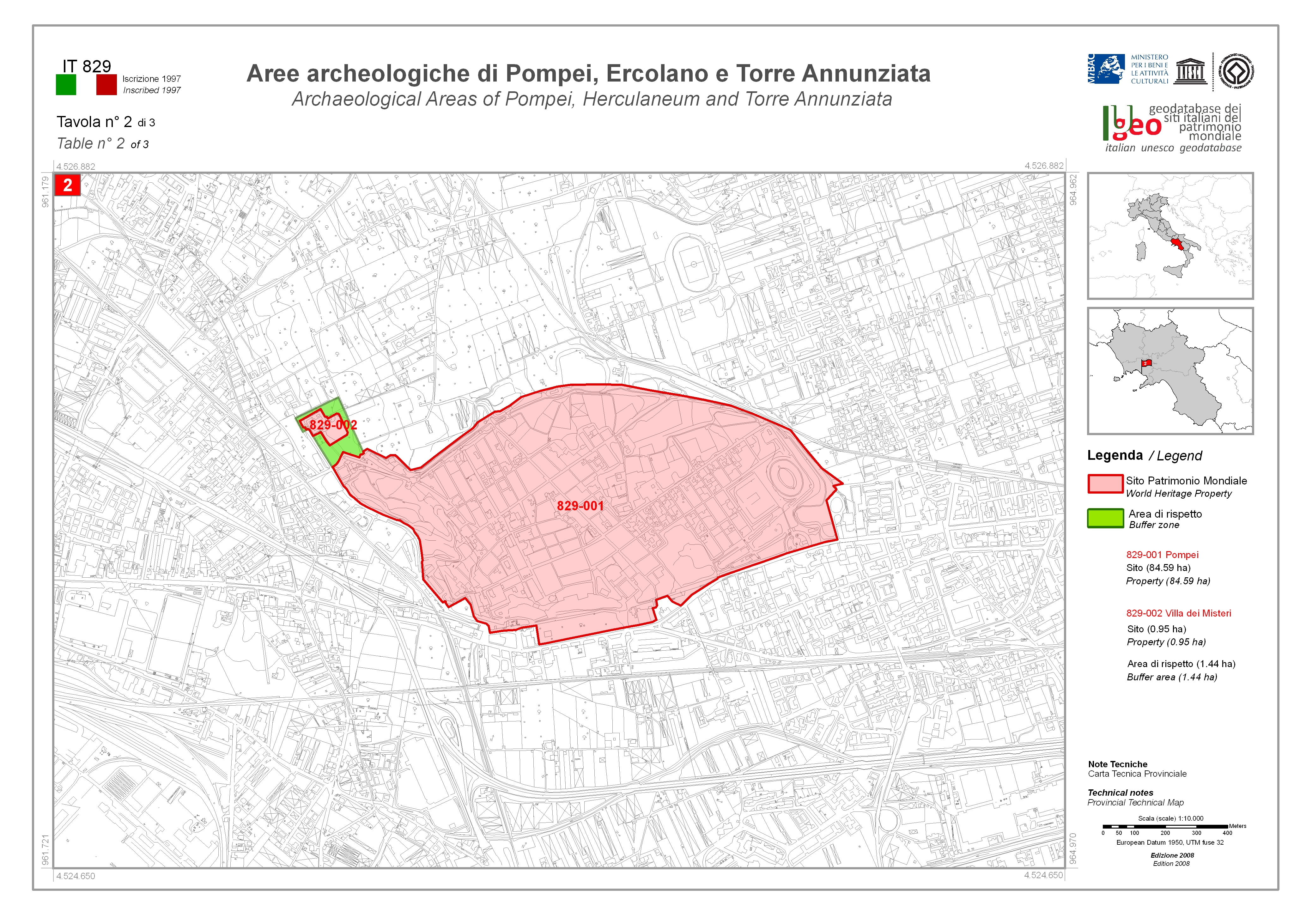
Pompeii 2008 World Heritage Zone
Plan of Pompeii in 2008 showing UNESCO world heritage zone.
Pompeii 2011
2011 SANP Plan of street altars and shrines in Pompeii.

Pompeii 2014
Comprehensive pompeiiinpictures plan of street altars and shrines in Pompeii.
To view the interactive version of this plan use the Altars button on the top of this page.
Pompeii 2014
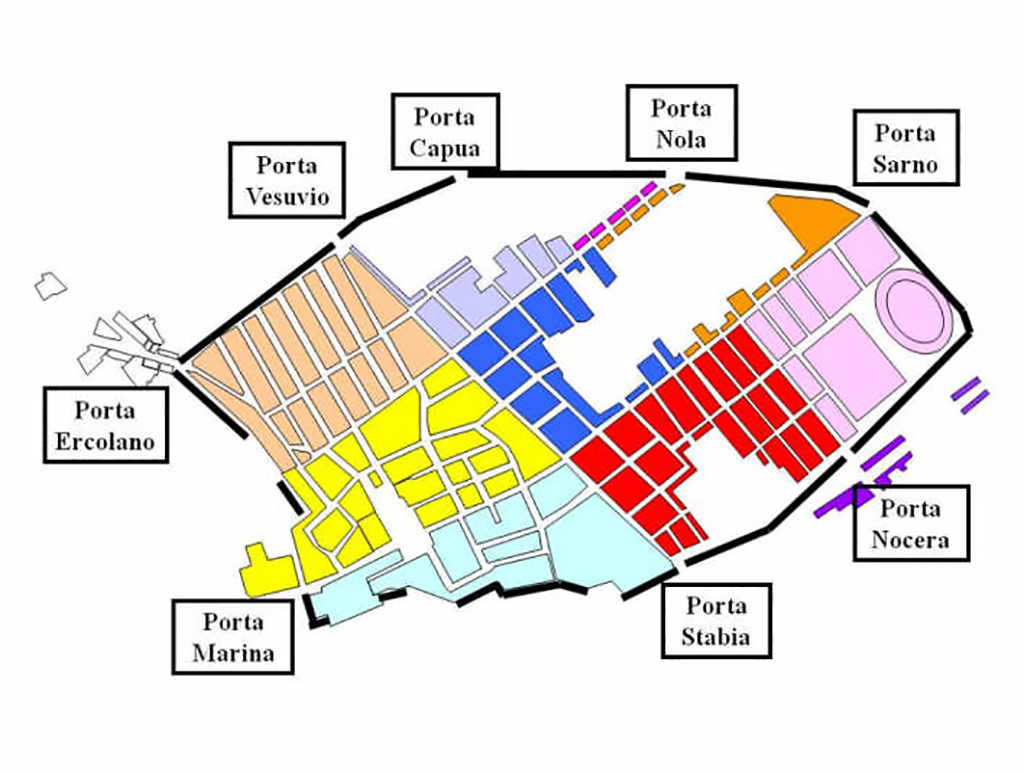
Current pompeiiinpictures plan of the gates of Pompeii.
To view the interactive version of this plan use the Gates button on the top of this page.
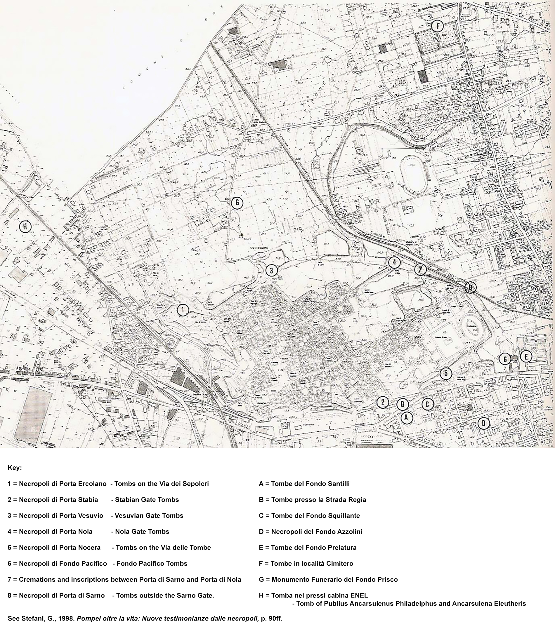
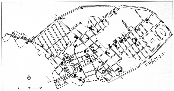
Pompeii 2014
Current pompeiiinpictures plan of tombs outside the gates and the area around Pompeii.
To view the interactive version of this plan use the Tombs button on the top of this page.
See Stefani, G., 1998. Pompei oltre la vita: Nuove testimonianze dalle necropoli, p. 90ff.
Pompeii 2014
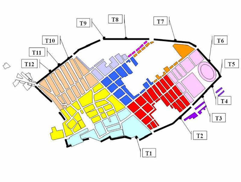
Current pompeiiinpictures plan of the towers around the walls of Pompeii.
To view the interactive version of this plan use the Towers button on the top of this page.

Pompeii 2014
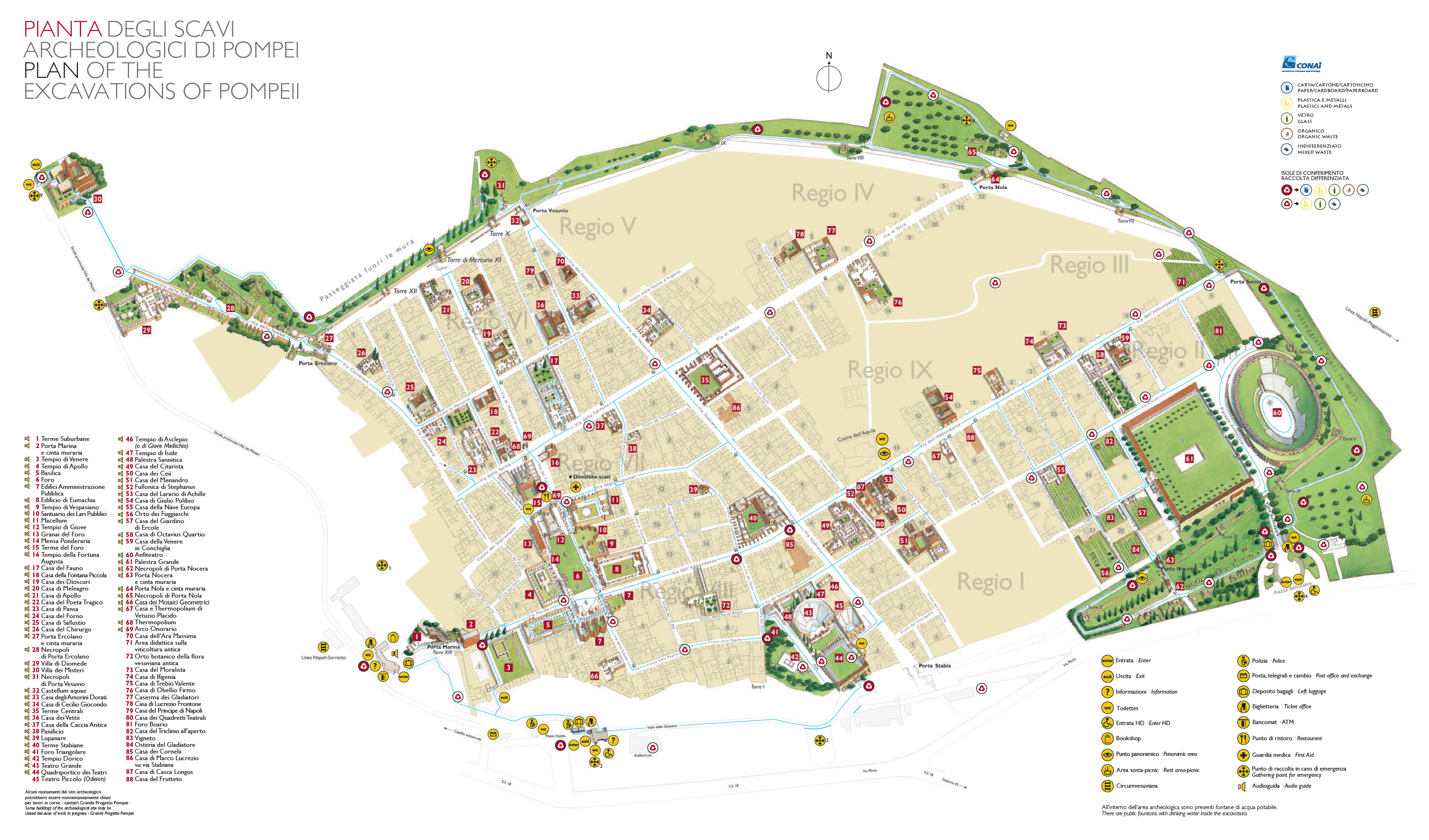
2014 Soprintendenza Pompeii tourist plan showing the main buildings. Not all of these are currently open to the public.
Pompeii 2015
2015 Soprintendenza Pompeii tourist plan showing the main buildings. Not all of these are currently open to the public.
Pompeii 2016
2016 Soprintendenza Pompeii tourist plan showing the main buildings. Not all of these are currently open to the public.

Pompeii 2017
Pompeii per Tutti
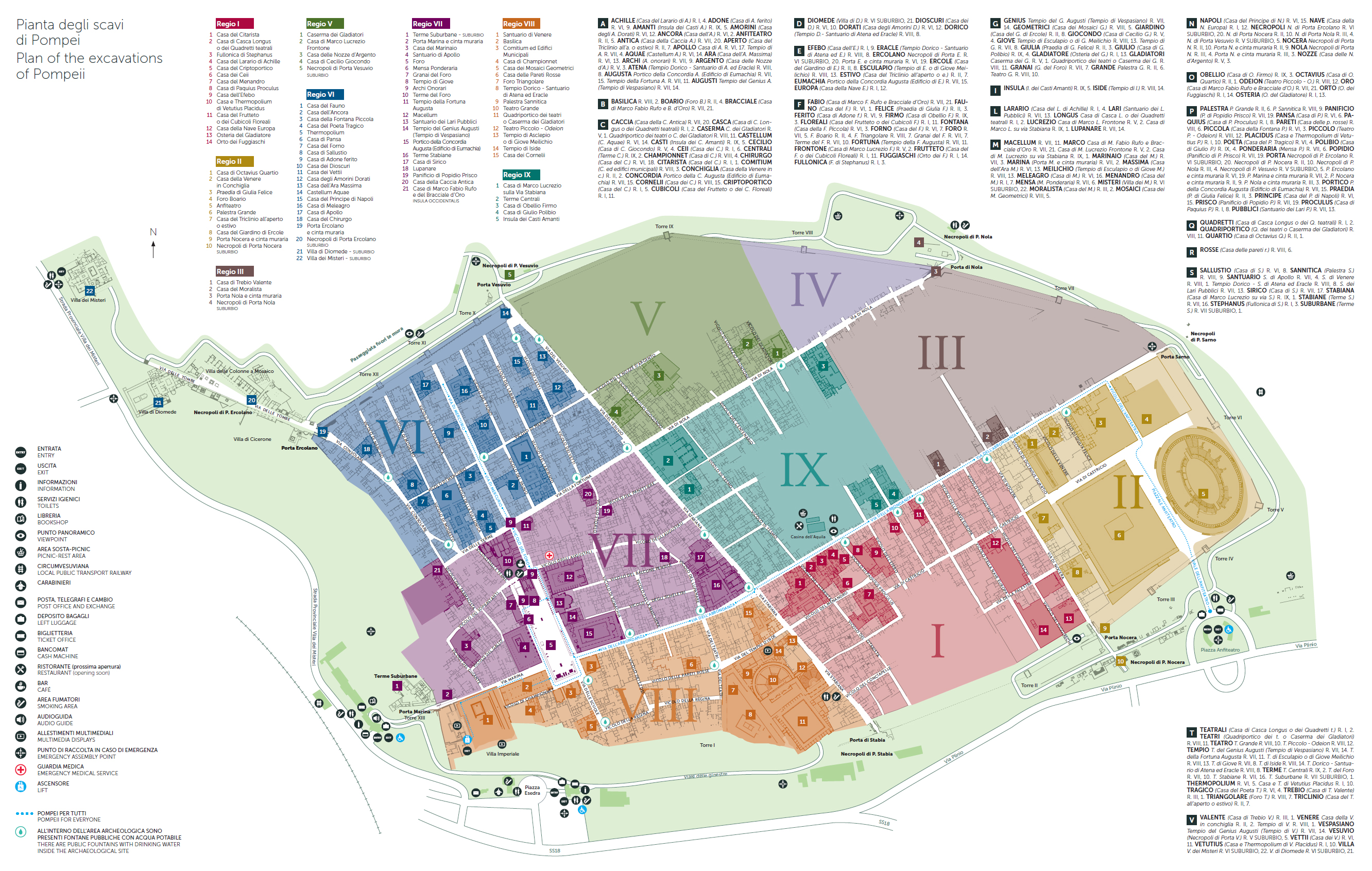
2017 Soprintendenza Pompeii "Pompeii per Tutti" plan showing the main buildings. Visitable buildings along the “Pompeii for All” routes are shown in bold. Not all of the buildings may currently be open to the public.

Pompeii 2017
Pompeii per Tutti accompanying narrative
2017 Soprintendenza Pompeii "Pompeii per Tutti" plan accompanying narrative showing details of entry, access, routes and visitable buildings along the “Pompeii for All” routes.

Pompeii 2017
2017 Parco Archeologico di Pompeii plan showing the increasing number of buildings open. Not all of the buildings may currently be open to the public.

Pompeii 2017
2017 Parco Archeologico di Pompeii plan's accompanying narrative showing details of entry, access, routes, itineries and visitable buildings.

Pompeii 2019
2019 Parco Archeologico di Pompeii tourist plan showing the main buildings. Not all of these are currently open to the public.

Pompeii 2019
2019 Parco Archeologico di Pompeii tourist plan itineries showing the main buildings. Not all of these are currently open to the public.

Pompeii 2020
pompeiiinpictures plan of fountains in Pompeii updated following recent excavations.
To view the interactive version of this plan use the Fountains button on the left of this page.

Pompeii 2020
pompeiiinpictures plan of every street in Pompeii updated following recent excavations.
To view the interactive version of this plan use the Streets button on the left of this page.

Pompeii 2020
June 2020 Parco Archeologico di Pompeii tourist plan itinery 1.

Pompeii 2020
June 2020 Parco Archeologico di Pompeii tourist plan itinery 2.
More Plans
If you have a plan which we could add to this page please email it to us, along with any details.
Soprintendenza: Guida/guide/guia/Leitfaden:
Piccola guida agli scavi di Pompei Italiano
Brief Guide to Pompeii English
Pequeña guía de Pompeya Espanol
Petit guide de Pompéi Francais
Kurzer Leitfaden zur Besichtigung von Pompeji Deutsch
Путеводитель по раскопкам города Помпеи Russian
ポンペイ遺跡ガイド Japanese
龐貝指南 Chinese
دليل بومبيي Arabic
Note 1: British officer’s account of Allied bombing at Pompeii. From The Times, 9 November, 1943.
'We have received from a British officer, who recently visited Pompeii, an account of the damage done to the place during September, when the Germans were encamped on the site and allied aircraft were obliged to treat it as a military objective. The following is a summary of the damage observed: “There is one crater in the arena of the Amphitheatre, and several near misses. The wall of the Gladiator's Training School was hit in three places. There is a crater in the eastern end of the Via dell' Abbondanza, to which incomplete excavation had prevented further damage. The houses of Rex Tiburtinus and of Trebius Valens were hit. The Cenacoli and house of Epidius Rufus were destroyed. The houses used for restorations north of the Via degli Augustali and the adjoining house were destroyed. The Temple of Jupiter on the western side of the Forum was hit. The Temple of Apollo and the House of Triptolemus north of the Via Marina were badly damaged. The Museum is now in ruins, but how much of the contents perished remains to be disclosed. The director of the excavations at Pompeii, Professor Maiuri, whose contributions to The Times will be remembered, was last heard of in a hospital at Torre del Greco with a leg injury received in an air raid.” 'The officer was told that two bombs had fallen on the Temple of Hercules in Region 8, and that the Houses of Sallust and Pansa in Region 6 had also received direct hits.'